 Filter: Categories of Wisconsin Historical Images
Filter: County of Dane
Filter: Subject of cities and towns
Filter: Subject of farms
Filter: Categories of Wisconsin Historical Images
Filter: County of Dane
Filter: Subject of cities and towns
Filter: Subject of farms

| Date: | 1873 |
|---|---|
| Description: | Main Street, with its dirt, ruts, cows (and presumably manure), but wide enough for easy hitching of wagons and teams. |
| Date: | 1900 |
|---|---|
| Description: | Wetland, grassy pasture, ring fence are part of the College of Agriculture Farm on the University of Wisconsin Madison campus. |
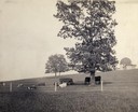
| Date: | 1900 |
|---|---|
| Description: | Fenced-in, the cattle find a grassy pasture of Observatory Hill below Washburn Observatory on the University of Wisconsin-Madison campus. |
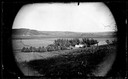
| Date: | 1873 |
|---|---|
| Description: | View across field towards the Amund Rustebakke farm. Twelve haystacks dominate the left and center of the image, and two people are standing on top of the ... |
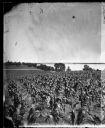
| Date: | 1875 |
|---|---|
| Description: | View from Southeast shore of Lake Monona across a cornfield, perhaps on the farm of Thomas Williamson. |

| Date: | 09 10 1875 |
|---|---|
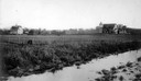
| Description: | View looking west across the area once occupied by Camp Randall during the Civil War and towards the Breese Stevens farm property. The Madison Centennial ... |
| Date: | 06 1925 |
|---|---|
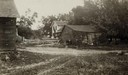
| Description: | View of three farm buildings - the one in the center is collapsing. |
| Date: | 02 21 1927 |
|---|---|
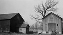
| Description: | Governor Taylor's farm with granary and barn. |

| Date: | 05 10 1928 |
|---|---|
| Description: | The Lutheran Church and buildings, seen from Lutheran Church Hill. |
| Date: | 1928 |
|---|---|
| Description: | View from hill of uptown Cross Plains with the Catholic Church (St. Francis Xavier) and farmhouses. |

| Date: | 1955 |
|---|---|
| Description: | Aerial view of Cross Plains, with countryside surrounding and hills on the horizon. |

| Date: | 11 1928 |
|---|---|
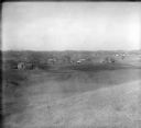
| Description: | Aerial view of Verona including businesses, houses, and the surrounding farm land. |

| Date: | 10 1928 |
|---|---|
| Description: | Aerial view of Sun Prairie, including the central business district, residences, and the surrounding countryside stretching to the horizon. |

| Date: | 11 1928 |
|---|---|
| Description: | Aerial view residential areas of Windsor and the surrounding countryside. |

| Date: | 11 1928 |
|---|---|
| Description: | Aerial view of Black Earth residential area and the surrounding countryside. |

| Date: | 11 1928 |
|---|---|
| Description: | Aerial view of Cross Plains, including residences and the surrounding countryside. |
| Date: | |
|---|---|
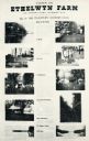
| Description: | Ethelwyn Farm (The Teachers' Country Club), on Lake Monona. |
If you didn't find the material you searched for, our Library Reference Staff can help.
Call our reference desk at 608-264-6535 or email us at:


