 Filter: Categories of Wisconsin Historical Images
Filter: County of Dane
Filter: Subject of church buildings
Filter: Subject of school buildings
Filter: Categories of Wisconsin Historical Images
Filter: County of Dane
Filter: Subject of church buildings
Filter: Subject of school buildings

| Date: | 1940 |
|---|---|
| Description: | Exterior view of the school of the Sacred Heart of Jesus and Mary. |
| Date: | 1910 |
|---|---|
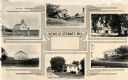
| Description: | Views of Stewart, Wisconsin (otherwise known as Postville or York Township) near Monroe, Dane County. Stewart post-office was established November 12, 186... |

| Date: | 1874 |
|---|---|
| Description: | View of the University of Wisconsin-Madison from the Wisconsin State Capitol. |
| Date: | 05 13 1961 |
|---|---|
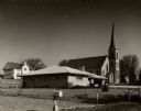
| Description: | Exterior of residence, parochial school, and church. There is a mailbox in the foreground. |
| Date: | 08 24 1885 |
|---|---|
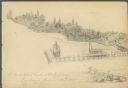
| Description: | Pencil on paper; promontory shoreline with houses, trees, and church in background sweeping to right, with long pier jutting into lake. Two boats tied to ... |

| Date: | 1904 |
|---|---|
| Description: | This 1904 map of Dane County, Wisconsin, shows postal routes, post office locations, towns, sections, cities and villages, roads, railroads, collection box... |

| Date: | 1908 |
|---|---|
| Description: | Panoramic view of Madison taken from Summit Avenue looking East South East toward Lake Monona. Included in the view are the Camp Randall bleachers, St. Rap... |

| Date: | 1914 |
|---|---|
| Description: | Shows land ownership by name, rural routes, improved roads, railroads, schools, churches, and cemeteries. "For list of small property owners, lift map at f... |

| Date: | 1888 |
|---|---|
| Description: | Shows ward divisions and street railways, as well as University of Wisconsin buildings, churches, and schools. Cataloged from copy with right and left edge... |

| Date: | 1929 |
|---|---|
| Description: | This is a blue line print map that shows local streets, railroads, local businesses, schools, parks, cemeteries, the airport, the state capitol, the Univer... |

| Date: | |
|---|---|
| Description: | Aerial view of the Capitol Square, with Capitol Park and part of the Wisconsin State Capitol. Manchester's is on the corner of Mifflin Street at Wisconsin ... |
| Date: | |
|---|---|
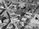
| Description: | Aerial view of Madison, including Yost's, State Street, The Orpheum Theatre, Hills, the Madison Public Library, block 64 parking, East Johnson Street, and ... |

| Date: | 1933 |
|---|---|
| Description: | Two signs are posted in an open area planted with young trees. One sign identifies the "Forest of Fame Mt. Vernon," and the other sign the "Elm Tree from B... |
If you didn't find the material you searched for, our Library Reference Staff can help.
Call our reference desk at 608-264-6535 or email us at: