 Filter: Categories of Wisconsin Historical Images
Filter: County of Dane
Filter: Subject of central business districts
Filter: Subject of school buildings
Filter: Categories of Wisconsin Historical Images
Filter: County of Dane
Filter: Subject of central business districts
Filter: Subject of school buildings
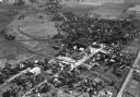
| Date: | 11 1928 |
|---|---|
| Description: | Aerial view of Oregon, including the central business disctrict, residential areas, schools, and the surrounding countryside. |

| Date: | 1955 |
|---|---|
| Description: | Shows city limits, adjoining municipalities, and schools. Indexes, illustrations, ancillary map of Dane County, and ancillary map of Madison business secti... |

| Date: | |
|---|---|
| Description: | Aerial view of the Capitol Square, with Capitol Park and part of the Wisconsin State Capitol. Manchester's is on the corner of Mifflin Street at Wisconsin ... |
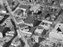
| Date: | |
|---|---|
| Description: | Aerial view of Madison, including Yost's, State Street, The Orpheum Theatre, Hills, the Madison Public Library, block 64 parking, East Johnson Street, and ... |

| Date: | 1945 |
|---|---|
| Description: | An aerial view, looking northeast, that includes the intersection at Atwood and Fair Oaks Avenues. Elmside Circle Park is on the bottom left. The Madison-K... |
If you didn't find the material you searched for, our Library Reference Staff can help.
Call our reference desk at 608-264-6535 or email us at: