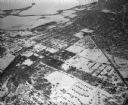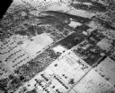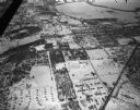
| Date: | 1930 |
|---|---|
| Description: | Aerial view of Hoyt Park including the surrounding neighborhoods. Resurrection Cemetery can be seen at the upper right of the image. |

| Date: | 02 06 1948 |
|---|---|
| Description: | Aerial photograph of Madison's west side looking northeast along Speedway Road. Visible are Forest Hill and Resurrection Cemeteries, West High School, Hoyt... |

| Date: | 02 06 1948 |
|---|---|
| Description: | Aerial view of west side, looking south along Glenway Street. Visible are the reservoir, Lake Wingra, Forest Hill and Resurrection Cemetery, Hoyt Park. Maj... |

| Date: | 02 06 1948 |
|---|---|
| Description: | Aerial photograph looking northwest across the reservoir on Glenway Street. Featured are Hoyt and Quarry Parks, Resurrection Cemetery. Major streets are Fr... |

| Date: | 02 06 1948 |
|---|---|
| Description: | Looking north along Glenway Street. Visible are the reservoir, Hoyt and Quarry Parks, Resurrection and Forest Hill Cemeteries, Rentschler Greenhouses, Fore... |

| Date: | 02 06 1948 |
|---|---|
| Description: | Looking southeast across Speedway Road. Visible are the reservoir on Glenway Street, Hoyt Park, Resurrection and Forest Hill cemeteries, Glenway Golf cours... |

| Date: | 1929 |
|---|---|
| Description: | This is a blue line print map that shows local streets, railroads, local businesses, schools, parks, cemeteries, the airport, the state capitol, the Univer... |

| Date: | 1956 |
|---|---|
| Description: | This map shows local streets, roads, railroads, highways, parks, cemeteries, hospitals, the University of Wisconsin, Middleton, Maple Bluff, Shorewood Hill... |

| Date: | 1971 |
|---|---|
| Description: | This map shows streets, highways, railroads, parks, colleges, cemeteries, county clubs, University of Wisconsin, Truax Field, Middleton, Shorewood Hills, M... |

| Date: | 1961 |
|---|---|
| Description: | This street map includes an ancillary map of Dane County highways and a business directory. Lake Mendota, Lake Monona, Monona Bay, Yahara River, and Lake W... |
If you didn't find the material you searched for, our Library Reference Staff can help.
Call our reference desk at 608-264-6535 or email us at: