 Filter: Categories of Wisconsin Historical Images
Filter: County of Dane
Filter: Subject of bridges
Filter: Subject of streams
Filter: Categories of Wisconsin Historical Images
Filter: County of Dane
Filter: Subject of bridges
Filter: Subject of streams

| Date: | 1876 |
|---|---|
| Description: | View of a farmstead with fences, haystacks and a wooden outbuilding. Two men are posing on top of McCord Rock, one of them saluting with his hat. Another ... |

| Date: | 1874 |
|---|---|
| Description: | Elevated view from hill of Clinton, now Rockdale. Three men are in the middle distance, looking east across Koshonong Creek towards a mill dam, bridge and ... |

| Date: | 1885 |
|---|---|
| Description: | A detail of a Sanborn map including Catfish Creek and Westport Road by Lake Mendota. |
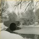
| Date: | 1940 |
|---|---|
| Description: | View from snowy shoreline towards a bridge over Wingra Creek, between Lake Wingra and Lake Monona, in Vilas Park. The road over the bridge leads into the U... |
If you didn't find the material you searched for, our Library Reference Staff can help.
Call our reference desk at 608-264-6535 or email us at: