 Filter: Categories of Wisconsin Historical Images
Filter: County of Dane
Filter: Subject of animals
Filter: Subject of indians of north america
Filter: Categories of Wisconsin Historical Images
Filter: County of Dane
Filter: Subject of animals
Filter: Subject of indians of north america
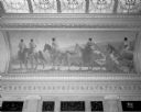
| Date: | 10 03 1934 |
|---|---|
| Description: | Mural depicting a party of Indians on horseback, on an upland, striking the trail (adapted from a photograph, by permission, made in the National Park). On... |
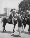
| Date: | 07 09 1930 |
|---|---|
| Description: | Mayor Albert G. Schmedeman greeting Chief Shunatuna, who is on horseback and who is in Madison with the Official United States Indian band at the RKO Orphe... |
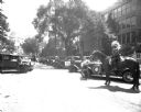
| Date: | 07 09 1930 |
|---|---|
| Description: | A man on a horse with Pontiac cars lined up on Wisconsin Avenue for the U.S. Indian Band parade, with the Wisconsin State Capitol in the background. They p... |
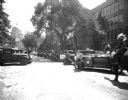
| Date: | 07 09 1930 |
|---|---|
| Description: | A man on a horse with Pontiac cars lined up on Wisconsin Avenue for the US Indian Band parade with State Capitol in the background. They played a concert a... |
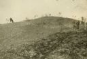
| Date: | 1909 |
|---|---|
| Description: | A horse grazes near Native American burial mounds on the Dividing Ridge, a recessional moraine, between Lakes Monona and Wingra in Madison, Wisconsin. The ... |

| Date: | 04 12 1912 |
|---|---|
| Description: | Diagram of a bird effigy mound found in Frost's Woods, Blooming Grove Township. |

| Date: | 1941 |
|---|---|
| Description: | Hand-drawn, watercolor and ink, map of Lake Mendota. Locations and many small figures appear around the shore with explanations referring to Indian legends... |

| Date: | |
|---|---|
| Description: | Back, front, and inside front cover of the menu from The Restaurant at Baron's department store, with "A Historical Map of Madison" focusing on the isthmus... |

| Date: | |
|---|---|
| Description: | A decorative map of Fuller's Woods development along the Lake Mendota shoreline. Includes numbered lots and building line setbacks with decorative features... |

| Date: | 1924 |
|---|---|
| Description: | This pictorial map focuses on the Madison Isthmus, Lake Mendota, Lake Monona, Lake Wingra, and shows points of historical interest, buildings, parks, and I... |
If you didn't find the material you searched for, our Library Reference Staff can help.
Call our reference desk at 608-264-6535 or email us at: