 Filter: Categories of Wisconsin Historical Images
Filter: County of Dane
Filter: Subject of aerial photographs
Filter: Subject of land use, urban
Filter: Categories of Wisconsin Historical Images
Filter: County of Dane
Filter: Subject of aerial photographs
Filter: Subject of land use, urban

| Date: | 1956 |
|---|---|
| Description: | Aerial view of the South Park Street interchange. |

| Date: | 1908 |
|---|---|
| Description: | A panoramic aerial view of the Isthmus taken from a kite. Lake Mendota is to the right in the background with Picnic Point jutting into the lake. The photo... |

| Date: | 05 09 1908 |
|---|---|
| Description: | Kite aerial panoramic photograph of the central business district. In the distance is Lake Mendota. The fire damaged Wisconsin State Capitol is in the cent... |

| Date: | 08 20 1930 |
|---|---|
| Description: | Aerial view of the Madison skyline from University of Wisconsin Field House, overlooking the Wisconsin State Capitol and, in the foreground, Gateway Lumber... |

| Date: | 1945 |
|---|---|
| Description: | View of the lower campus of the University of Wisconsin-Madison includes Bascom Hill, Wisconsin Historical Society, Memorial Union and the Armory (Red Gym ... |

| Date: | 1926 |
|---|---|
| Description: | Originally titled 'Recent Aeroplane View of University Campus', the view of the Wisconsin Historical Society, the Red Gym, Science Hall and Bascom Hall wit... |

| Date: | 1955 |
|---|---|
| Description: | Aerial view of Cross Plains, with countryside surrounding and hills on the horizon. |

| Date: | 1922 |
|---|---|
| Description: | Aerial view of the Wisconsin State Capitol and Lake Monona. |

| Date: | 1957 |
|---|---|
| Description: | Aerial view of the north corner of Capitol Square looking toward Lake Mendota. The Belmont Hotel is featured prominently. |

| Date: | 1956 |
|---|---|
| Description: | Aerial view looking northeast from a point over the east end of Middleton, showing the west end of Lake Mendota (right mid-ground). Fox Bluff juts into the... |

| Date: | 1919 |
|---|---|
| Description: | Aerial view with the Wisconsin State Capitol in the foreground, and the tip of Monona Bay and Lake Wingra to the left, with horizon stretching into the dis... |

| Date: | 1955 |
|---|---|
| Description: | Aerial view of Atwood Avenue, looking west towards Winnebago Street and "Schenk's Corners." |

| Date: | 1930 |
|---|---|
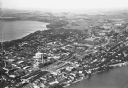
| Description: | Aerial view of isthmus looking east toward Lake Mendota and the Wisconsin State Capitol, with Lake Monona and the horizon in the background. |

| Date: | 1953 |
|---|---|
| Description: | Aerial view looking southeast over Madison's near east side. The Eagles Club at 1236 Jenifer Street / 1221 Williamson Street is under construction in the ... |
| Date: | |
|---|---|
| Description: | Aerial view looking northeast towards the east side of Madison between Lake Monona and Lake Mendota, from Blair Street to the Yahara River. |
| Date: | 10 1928 |
|---|---|
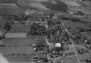
| Description: | Aerial view of DeForest including residences and the surrounding countryside. |
| Date: | 1930 |
|---|---|
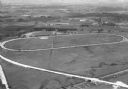
| Description: | Aerial view of the Dane County fairgrounds, including several buildings and a track. |
If you didn't find the material you searched for, our Library Reference Staff can help.
Call our reference desk at 608-264-6535 or email us at:


