 Filter: Categories of Wisconsin Historical Images
Filter: County of Dane
Filter: Subject of aerial photographs
Filter: Subject of commercial buildings
Filter: Categories of Wisconsin Historical Images
Filter: County of Dane
Filter: Subject of aerial photographs
Filter: Subject of commercial buildings

| Date: | 08 28 1970 |
|---|---|
| Description: | An aerial view of West Towne Shopping Center (now West Towne Mall) at Mineral Point and Gammon Roads. |

| Date: | 1928 |
|---|---|
| Description: | Aerial view of the Wisconsin State Capitol, looking northeast. The Park Hotel on the corner of W. Main Street and S. Carroll Street, is in the foreground. |
| Date: | 12 14 1931 |
|---|---|
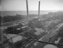
| Description: | Aerial view of Madison industrial district taken from the top of the Madison Gas and Electric Co. gas tank looking south west down the 600 and 700 blocks o... |

| Date: | 1957 |
|---|---|
| Description: | Aerial view of the north corner of Capitol Square looking toward Lake Mendota. The Belmont Hotel is featured prominently. |

| Date: | 1953 |
|---|---|
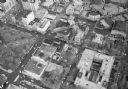
| Description: | Aerial view looking southeast over Madison's near east side. The Eagles Club at 1236 Jenifer Street / 1221 Williamson Street is under construction in the ... |

| Date: | 08 08 1976 |
|---|---|
| Description: | Aerial view of the textured steel roof atop the East Towne office of the First Wisconsin National Bank, 4602 East Towne Boulevard. |
| Date: | |
|---|---|
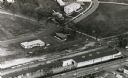
| Description: | Aerial view of University Avenue near the Veteran's Administration Hospital. At the bottom is the J.S. Timlin Lumber Company. |

| Date: | 1959 |
|---|---|
| Description: | Aerial view of the Westgate Shopping Center under construction. |

| Date: | 01 15 1964 |
|---|---|
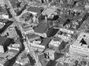
| Description: | Aerial photograph of the intersection of Mifflin, Pinckney, and Hamilton streets on Madison's Capitol Square. The Madison Hotel, 108 North Pinckney Street,... |
| Date: | |
|---|---|
| Description: | Aerial view of Madison, including the Capitol Square on the left at Mifflin and State Street, and Central High School, the light-colored building in the fo... |

| Date: | |
|---|---|
| Description: | Aerial view of the Capitol Square, with Capitol Park and part of the Wisconsin State Capitol. Manchester's is on the corner of Mifflin Street at Wisconsin ... |
| Date: | |
|---|---|
| Description: | Aerial view of Madison, including Yost's, State Street, The Orpheum Theatre, Hills, the Madison Public Library, block 64 parking, East Johnson Street, and ... |

| Date: | |
|---|---|
| Description: | Aerial view of Madison featuring Central High School/Madison Area Technical College (MATC) at top center. |

| Date: | 1945 |
|---|---|
| Description: | An aerial view, looking northeast, that includes the intersection at Atwood and Fair Oaks Avenues. Elmside Circle Park is on the bottom left. The Madison-K... |

| Date: | 1950 |
|---|---|
| Description: | Aerial view of the Wisconsin State Capitol and Square. |

| Date: | |
|---|---|
| Description: | Aerial view looking north along Stoughton Road from south of Pflaum Road. |

| Date: | 1942 |
|---|---|
| Description: | Aerial view of Capitol Square with Lake Monona in the foreground and Lake Mendota in the background. Pinckney Street is on the right. |
If you didn't find the material you searched for, our Library Reference Staff can help.
Call our reference desk at 608-264-6535 or email us at: