Filter: Categories of Wisconsin Historical Images
Filter: County of Dane
Filter: Reproduction Rights of For Sale
Filter: Type of Map or Atlas
Filter: Categories of Wisconsin Historical Images
Filter: County of Dane
Filter: Reproduction Rights of For Sale
Filter: Type of Map or Atlas

| Date: | 1873 |
|---|---|
| Description: | A plat map of the town of Pleasant Springs. |

| Date: | 1899 |
|---|---|
| Description: | A plat map of the township of Christiana. |

| Date: | 1873 |
|---|---|
| Description: | A page showing four plat maps: Stoughton, Clifton, Deanville, and Cross Plains. |

| Date: | 10 1894 |
|---|---|
| Description: | A Sanborn Fire Insurance Map of Waunakee. |

| Date: | |
|---|---|
| Description: | This map of Madison is also a brochure of activities for vacationers in the area. Includes indexes and some points of interest shown pictorially. |

| Date: | |
|---|---|
| Description: | The cover of a map which is titled: "Visit Madison Wisconsin the Capital of Vacationland". The cover lists various places to visit in the city. |

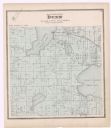
| Date: | 1899 |
|---|---|
| Description: | A plat map of Pleasant Springs in Dane County. |

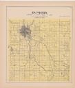
| Date: | 1899 |
|---|---|
| Description: | A plat map of Burke, Cottage Grove, McFarland, Waunakee, Quarry Town, Klevenville, and Vilas. |

| Date: | 1908 |
|---|---|
| Description: | A Sanborn map including a portion of the East Johnson Street and East Gorham Street neighborhood. |
If you didn't find the material you searched for, our Library Reference Staff can help.
Call our reference desk at 608-264-6535 or email us at: