 Filter: Categories of Wisconsin Historical Images
Filter: County of Crawford
Filter: Categories of Wisconsin Historical Images
Filter: County of Crawford
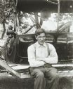
| Date: | 1914 |
|---|---|
| Description: | View of a man, who is apparently blind in one eye, sitting on the running board of a Model T Ford touring automobile outdoors. A young girl is sitting in t... |

| Date: | 1910 |
|---|---|
| Description: | Interior of Koska Hall on the third floor of Campion Jesuit High School. This was used as a study hall. |
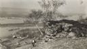
| Date: | 1915 |
|---|---|
| Description: | Elevated view of the Mississippi River from a bluff. There is a farm and other houses along the shoreline, and in the foreground a boy stands on the bluff ... |

| Date: | 1890 |
|---|---|
| Description: | This is a plat map of "Wauzeeka" drawn in pencil. The map shows numbered lots, labeled streets, the Kickapoo River, and railroads. The map reads: "Laid out... |
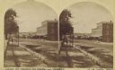
| Date: | 1875 |
|---|---|
| Description: | Stereograph view of Black Hawk Avenue. |

| Date: | 1859 |
|---|---|
| Description: | Steam-powered car designed to run on ice across the Mississippi River at Prairie du Chien. The LADY FRANKLIN made one successful trip across, but wa... |
| Date: | 1912 |
|---|---|
| Description: | View along Main Street of shops, horses and townspeople. |

| Date: | 06 01 1985 |
|---|---|
| Description: | William Meyer, owner of the Kickapoo Orchard at Gays Mills, adds pollen to beehives to help in pollination. |

| Date: | 09 10 1961 |
|---|---|
| Description: | Kickapoo Valley landscape with a dead white tree in the vicinity of Highway 131. |

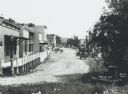
| Date: | 1909 |
|---|---|
| Description: | View from street of storefronts, Post Office and group of bystanders. |

| Date: | 2004 |
|---|---|
| Description: | Holstein cows resting on a sunny day in a hilltop pasture. View to horizon towards wooded hills with clouds in the sky. |
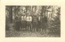
| Date: | 12 24 1935 |
|---|---|
| Description: | Christmas photographic postcard to C.L. Harrington from: David Wedgwood, Ben King, Marvin F Hartman, Bryan W. Brewer, Joseph L. Young, Bill Fischer, Jim Da... |

| Date: | 07 04 1965 |
|---|---|
| Description: | Text on back of Pairing, "Sunrise on treetops along the north shore of the Wisconsin River, near Boscobel, but in Crawford County." Fog fills the middle gr... |

| Date: | 1882 |
|---|---|
| Description: | This map is ink on cardboard and shows the location of military forts over the course of years. Also shown are points of interest, streets, the Mississippi... |

| Date: | 1864 |
|---|---|
| Description: | This map is ink, pencil, and color on paper and shows numbered lots and labeled streets. The bottom margin of the map reads: "Recorded in the Registry of d... |

| Date: | 01 15 1929 |
|---|---|
| Description: | Intended for tourists, this brochure, titled: "Winneshiek World’s Famous Wild Life Refuge Historic Fort Crawford and Picturesque Prairie du Chien," feature... |

| Date: | 1950 |
|---|---|
| Description: | Intended for tourists, this brochure features two maps with tourists sites along the Mississippi River. One map shows roads and populated places along the ... |

| Date: | 1976 |
|---|---|
| Description: | This map includes an index of streets, government and historic buildings, hospitals, schools, places of recreation, churches, cemeteries, and other miscell... |

| Date: | 1800 |
|---|---|
| Description: | This map is ink and watercolor on paper and shows the main channel and sand bars in the Mississippi River between villages. |

| Date: | 1830 |
|---|---|
| Description: | This map is ink, color, and pencil on paper and shows streets, farm lots, and a church. Handwritten notes are at the bottom of the map and are very light. |
If you didn't find the material you searched for, our Library Reference Staff can help.
Call our reference desk at 608-264-6535 or email us at: