Filter: Categories of Wisconsin Historical Images
Filter: County of Crawford
Filter: Year of 1900-1999
Filter: Subject of transportation
Filter: Categories of Wisconsin Historical Images
Filter: County of Crawford
Filter: Year of 1900-1999
Filter: Subject of transportation
| Date: | 1916 |
|---|---|
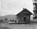
| Description: | Exterior view of the Bell Center depot with five men posing on the platform. |
| Date: | 1912 |
|---|---|
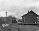
| Description: | View down railroad tracks of a locomotive arriving at the Barnum Depot. |

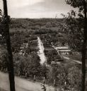
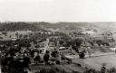
| Date: | 1905 |
|---|---|
| Description: | Elevated view of Soldiers' Grove with a bridge in the foreground. |
| Date: | 10 20 1928 |
|---|---|
| Description: | View of the Stone Crushing Plant on Hwy #27 near Soldiers Grove. |
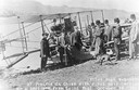
| Date: | 10 19 1911 |
|---|---|
| Description: | Pilot Hugh Robinson and his Curtiss hydroplane at Prairie du Chien during a flight that was intended to be the first all the way down the Mississippi River... |
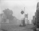
| Date: | 08 20 1961 |
|---|---|
| Description: | Street scene with a Shell gasoline station, the Kitty Korner Kafe, and a phone booth in early morning fog. |
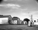
| Date: | 07 05 1965 |
|---|---|
| Description: | Street corner with gasoline station, 7-Up sign in front of restaurant next door, and several storefronts across the street. |

| Date: | 10 20 1928 |
|---|---|
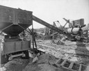
| Description: | Elevated view of the stone crushing plant of the Wisconsin Foundry and Machine Company on Highway 27 near Soldiers Grove, showing a truck being filled with... |
| Date: | 10 19 1911 |
|---|---|
| Description: | Aviator Hugh Robinson and his Curtiss flying boat on the Mississippi River. |
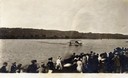
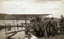
| Date: | 10 19 1911 |
|---|---|
| Description: | A crowd gathered on the Mississippi River shoreline near Prairie du Chien. They are watching pioneer aviator Hugh Robinson taxi his Curtiss flying boat. |
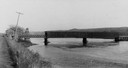
| Date: | 1900 |
|---|---|
| Description: | View from road of a partially covered bridge. Industrial buildings are near the entrance to the bridge on the left. |
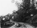
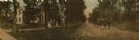
| Date: | 1911 |
|---|---|
| Description: | View of a dirt road winding through a forested area. A building is up the hill to the right of the road. |
| Date: | 1950 |
|---|---|
| Description: | View from hill through two trees over a road with a guard fence, overlooking the town laid out along a main thoroughfare. The area is heavily forested, and... |
| Date: | 1946 |
|---|---|
| Description: | Elevated view from hill of Gays Mills. Tree-covered hills are in the distance. |

| Date: | 1908 |
|---|---|
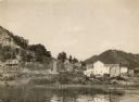
| Description: | Elevated view of Wauzeka. A bridge over a river is in the background. |

| Date: | 09 1962 |
|---|---|
| Description: | The Mississippi River along Highway 35. |
| Date: | 1900 |
|---|---|
| Description: | Dr. Jesse Rowley is driving the buggy on the road. Dr. Rowley was a co-founder of the Hospital for Rheumatic Diseases in Prairie du Chien, Wisconsin. Peopl... |

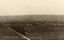
| Date: | 10 1905 |
|---|---|
| Description: | Elevated view from Reservoir Bluff to the east of the town. The bluffs of Iowa can be seen in the distance. |
| Date: | 1930 |
|---|---|
| Description: | Elevated view of the north side of town, from high on the bluff. Caption reads: "'Birdseye' No. End Prairie Du Chien, Wis." |
If you didn't find the material you searched for, our Library Reference Staff can help.
Call our reference desk at 608-264-6535 or email us at: