 Filter: Categories of Wisconsin Historical Images
Filter: County of Crawford
Filter: Year of 1800-1899
Filter: Year of 1820-1829
Filter: Categories of Wisconsin Historical Images
Filter: County of Crawford
Filter: Year of 1800-1899
Filter: Year of 1820-1829
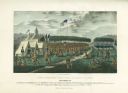
| Date: | 09 1825 |
|---|---|
| Description: | Treaty at Prairie du Chien, with Fort Crawford seen in the background. This treaty negotiated between Governor William Clark and Governor Lewis Cass and ov... |

| Date: | 10 1829 |
|---|---|
| Description: | Fort Crawford as drawn by Seth Eastman. People are in a canoe in the river in the foreground. Across the river is the fort, other buildings around the fort... |

| Date: | 1825 |
|---|---|
| Description: | Kitch-ee-i-aa-ba, or the Big Buck, a Chippewa (Ojibwa) Chief. Hand-colored lithograph from the Aboriginal Portfolio, painted at the treaty of Prarie du Chi... |

| Date: | 1820 |
|---|---|
| Description: | A manuscript map of Prairie du Chien. |

| Date: | 1821 |
|---|---|
| Description: | A topographical view of the site of Fort Crawford. |

| Date: | 1823 |
|---|---|
| Description: | British evacuation of their fort at Prairie du Chien after the end of the War of 1812. Fort Shelby, the first fort at Prairie du Chien, was built in 1814 b... |

| Date: | 1829 |
|---|---|
| Description: | Fort Crawford, from a sketchbook attributed to Seth Eastman, 1808-1875. A graduate of West Point, Eastman briefly served at Fort Crawford, 1829-1839. |

| Date: | 1829 |
|---|---|
| Description: | Photoprint of Crawford County lead district map. |

| Date: | 1828 |
|---|---|
| Description: | Plat of the Private Claims at Prairie Du Chien. |

| Date: | 1820 |
|---|---|
| Description: | This map displays the plan for claiming various settlement zones in the Prairie des Chiens area in 1820. It shows Fort Crawford and 87 confirmed and unconf... |

| Date: | 1828 |
|---|---|
| Description: | This plat map is pen-and-ink and shows landowners, the Mississippi River, the Marais de St. Friole, Fort Crawford, the town commons, and the Village of St.... |

| Date: | 1828 |
|---|---|
| Description: | This map is pen-and-ink and served as the model for the lithograph produced in 1828 by C.B. Graham. Landowners are labeled as is the Mississippi River. |
If you didn't find the material you searched for, our Library Reference Staff can help.
Call our reference desk at 608-264-6535 or email us at: