 Filter: Categories of Wisconsin Historical Images
Filter: County of Crawford
Filter: Year of 1800-1899
Filter: Year of 1850-1859
Filter: Subject of water
Filter: Categories of Wisconsin Historical Images
Filter: County of Crawford
Filter: Year of 1800-1899
Filter: Year of 1850-1859
Filter: Subject of water

| Date: | 1856 |
|---|---|
| Description: | This map shows lot and block numbers, streets, a mill, the Milwaukee and Mississippi Railroad, the train depot, and the Kickapoo River. Included in the low... |

| Date: | 06 1853 |
|---|---|
| Description: | This map is ink, pencil, and color on paper and shows lot and block numbers and dimensions, sold lots, streets, and the Mississippi River. Some lots are co... |

| Date: | 1856 |
|---|---|
| Description: | This map shows lot and block numbers, streets, the Mississippi River, Fort Crawford, depot ground, and a graveyard. An old fort location is outlined in red... |

| Date: | 12 05 1854 |
|---|---|
| Description: | This plat map shows landowners, the Mississippi River, the Marais de St. Friole, and an old fort. The left margin reads: "Part of the Main Village of Prair... |

| Date: | 05 21 1855 |
|---|---|
| Description: | This plat map shows lots, the Kickapoo River, and the Wisconsin River. |
| Date: | 1856 |
|---|---|
| Description: | This map is ink and watercolor on paper and includes certifications inscribed by Saml. T. [M?]ight, a civil engineer, Edward H. Brodhead, James H. Lockwood... |

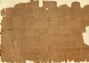
| Date: | 1856 |
|---|---|
| Description: | This map is ink and color on paper and mounted on cloth. The map shows lot and block numbers, streets, a railroad, and the Kickapoo River. Some lots are c... |
If you didn't find the material you searched for, our Library Reference Staff can help.
Call our reference desk at 608-264-6535 or email us at: