 Filter: Categories of Wisconsin Historical Images
Filter: County of Crawford
Filter: Year of 1800-1899
Filter: Subject of roads
Filter: Categories of Wisconsin Historical Images
Filter: County of Crawford
Filter: Year of 1800-1899
Filter: Subject of roads

| Date: | 1884 |
|---|---|
| Description: | Bird's-eye view drawing of the grounds of Villa Louis, the estate of the fur trading Dousman family. After the death of H. Louis Dousman's mother in 1882, ... |

| Date: | 1895 |
|---|---|
| Description: | View down road with the Bay State House on the left. Three houses and a barbershop also line the street. A lamppost is in the left foreground. The Mississ... |
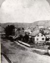
| Date: | 1870 |
|---|---|
| Description: | One-half stereograph of town, elevated view looking northeast from Case's Block. |

| Date: | 1830 |
|---|---|
| Description: | This early 19th century manuscript map of Prairie du Chien, Wisconsin, shows sections, landownership and acreages, roads, and ferries in the towns of Bridg... |

| Date: | 1878 |
|---|---|
| Description: | This map of Crawford County, Wisconsin, shows the township and range grid, sections, towns, cities and villages, land ownership and acreages, roads, railro... |
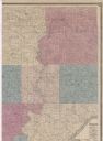
| Date: | 1878 |
|---|---|
| Description: | Portion of a map of Crawford County. |
If you didn't find the material you searched for, our Library Reference Staff can help.
Call our reference desk at 608-264-6535 or email us at: