Filter: Categories of Wisconsin Historical Images
Filter: County of Crawford
Filter: Year of 1800-1899
Filter: Subject of land use
Filter: Categories of Wisconsin Historical Images
Filter: County of Crawford
Filter: Year of 1800-1899
Filter: Subject of land use
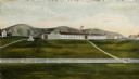
| Date: | 1840 |
|---|---|
| Description: | Photograph of a painting of the second Fort Crawford, built 1829-1835. Two men are in a boat in the water in the foreground. The first Fort Crawford at Pra... |
| Date: | 1880 |
|---|---|
| Description: | Elevated view of Artesian Well, located near the intersection of Wisconsin Street and South Minnesota Street (since renamed Wacouta). It was dubbed by some... |

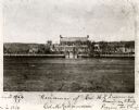
| Date: | 1884 |
|---|---|
| Description: | Bird's-eye view drawing of the grounds of Villa Louis, the estate of the fur trading Dousman family. After the death of H. Louis Dousman's mother in 1882, ... |
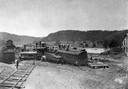
| Date: | 1898 |
|---|---|
| Description: | Elevated view of the Kickapoo & Northern Railway locomotive and cars seen here after being derailed due to flooding on the Kickapoo River. |

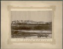
| Date: | 1830 |
|---|---|
| Description: | Illustration of Fort Crawford. Caption reads: "Fort Crawford in 1830, Prairie Du Chien, Wis." |
| Date: | 1860 |
|---|---|
| Description: | View from field of Villa Louis, the residence of Hercules L. Dousman. |
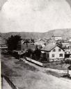
| Date: | 1870 |
|---|---|
| Description: | One-half stereograph of town, elevated view looking northeast from Case's Block. |
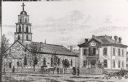
| Date: | 1887 |
|---|---|
| Description: | St. Gabriel's Roman Catholic Church. Horse-drawn vehicles and pedestrians are on the street and sidewalk in front of the church. |
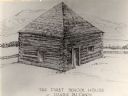
| Date: | 1840 |
|---|---|
| Description: | The first school house at Prairie du Chien, Wisconsin. There is a fence behind the building, and hills in the background. |

| Date: | 1828 |
|---|---|
| Description: | Plat of the Private Claims at Prairie Du Chien. |
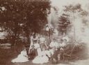
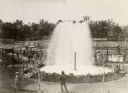
| Date: | 1898 |
|---|---|
| Description: | Group of twelve people, including Nina Dousman, gathered around a table outdoors, with a fountain spouting water in the background. Four people play cards ... |

| Date: | 1878 |
|---|---|
| Description: | This map of Crawford County, Wisconsin, shows the township and range grid, sections, towns, cities and villages, land ownership and acreages, roads, railro... |

| Date: | 1830 |
|---|---|
| Description: | This map is ink, color, and pencil on paper and shows streets, farm lots, and a church. Handwritten notes are at the bottom of the map and are very light. |

| Date: | 1838 |
|---|---|
| Description: | This map is a development plat that shows street names, numbered blocks and lots, and small farm lot owners. Included on the right of the map is a large am... |

| Date: | 1856 |
|---|---|
| Description: | This map shows lot and block numbers, streets, the Mississippi River, Fort Crawford, depot ground, and a graveyard. An old fort location is outlined in red... |

| Date: | 1857 |
|---|---|
| Description: | This map shows lots and streets and includes pencil manuscript notations on the front and certification statements on the reverse. The top left margin read... |

| Date: | 09 01 1856 |
|---|---|
| Description: | This map is pen-and-ink and shows farm lots, other lots of land sectioned by acres, bluffs, and a coulee. Also included are notations in pencil and blue in... |

| Date: | 1855 |
|---|---|
| Description: | This map shows streets and lots. The right side of the map includes notes on widths of streets and certifications. The top right reads: "Parish's Addition ... |

| Date: | 1865 |
|---|---|
| Description: | This is a collection of two plat maps. The first map shows lots, streets, and farm lot 25. Written in ink, the top of the map reads: Plat of Prairie du Chi... |
If you didn't find the material you searched for, our Library Reference Staff can help.
Call our reference desk at 608-264-6535 or email us at: