 Filter: Categories of Wisconsin Historical Images
Filter: County of Crawford
Filter: Year of 1800-1899
Filter: Subject of architecture
Filter: Categories of Wisconsin Historical Images
Filter: County of Crawford
Filter: Year of 1800-1899
Filter: Subject of architecture
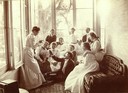
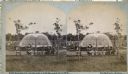
| Date: | 1898 |
|---|---|
| Description: | Group of people on the front porch, weighing the guests. A visit was considered successful if the guests weighed more when they left. |

| Date: | 10 1829 |
|---|---|
| Description: | Fort Crawford as drawn by Seth Eastman. People are in a canoe in the river in the foreground. Across the river is the fort, other buildings around the fort... |
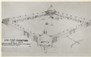
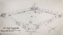
| Date: | 1817 |
|---|---|
| Description: | Elevated view of Old Fort Crawford. Caption reads: "Log Fort Crawford 1816-1829 Sketch Made From, Maj. S.H. Long's Description of 1817." |
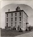
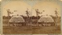
| Date: | 1872 |
|---|---|
| Description: | Alleged to be the earliest known view of St. Mary's Institute, which later became St. Mary's College. One-half of a stereograph. |
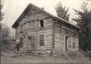
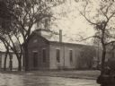
| Date: | 1870 |
|---|---|
| Description: | The first Norwegian Lutheran church in Crawford County; a log structure with man standing in front. |
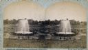
| Date: | 1880 |
|---|---|
| Description: | Stereograph of the Artesian Well near the intersection of Wisconsin and Minnesota (later renamed Wacouta) Streets. The following is printed on the back of ... |
| Date: | 1880 |
|---|---|
| Description: | Stereograph of the Artesian Well near the intersection of Wisconsin and Minnesota (later renamed Wacouta) Streets. The following is printed on the backside... |

| Date: | 1895 |
|---|---|
| Description: | View down road with the Bay State House on the left. Three houses and a barbershop also line the street. A lamppost is in the left foreground. The Mississ... |

| Date: | 1898 |
|---|---|
| Description: | View from water tower, showing the grove where Black Hawk's pursuers were supposed to have camped in 1832. The group of men in the foreground are digging f... |

| Date: | 1836 |
|---|---|
| Description: | Woodcut of Prairie du Chien in 1836. Text at bottom reads: "Prairie du Chien in 1836. From an old cut." |
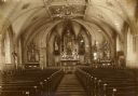
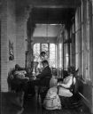
| Date: | 1890 |
|---|---|
| Description: | A view of the interior of St. Gabriel's Church. |
| Date: | 1814 |
|---|---|
| Description: | Fort Shelby built in 1814 and named for the Governor of Kentucky, was surrendered to British forces later in 1814 and renamed Fort McKay. Pictured here is ... |
| Date: | 1817 |
|---|---|
| Description: | Sketch of an elevated view of Fort Crawford (1816-1829). |

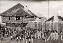
| Date: | 1890 |
|---|---|
| Description: | Elevated view across street towards the Dousman Office building, later used as a pearl button factory. A large group of people are sitting and standing at ... |
| Date: | 1880 |
|---|---|
| Description: | Congregational church, organized in 1852. |
| Date: | 1890 |
|---|---|
| Description: | The Astor Company or Brisbois fur trading post. |
| Date: | 1880 |
|---|---|
| Description: | Stereograph of an artesian well, located near the intersection of Wisconsin Street and South Minnesota Street (since renamed Wacouta). Construction was com... |
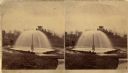
| Date: | 1876 |
|---|---|
| Description: | Stereograph of artesian well, located near the intersection of Wisconsin Street and South Minnesota Street (since renamed Wacouta). |
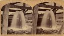
| Date: | 1875 |
|---|---|
| Description: | Stereograph of artesian well, apparently not the same one that was located near the intersection of Wisconsin Street and South Minnesota Street (since rena... |
| Date: | 1898 |
|---|---|
| Description: | The Dousman family and friends on the east porch of Villa Louis. |
If you didn't find the material you searched for, our Library Reference Staff can help.
Call our reference desk at 608-264-6535 or email us at: