Filter: Categories of Wisconsin Historical Images
Filter: County of Crawford
Filter: Subject of human settlements
Filter: Categories of Wisconsin Historical Images
Filter: County of Crawford
Filter: Subject of human settlements

| Date: | 1906 |
|---|---|
| Description: | Bluff Street looking east. Pedestrians are on the sidewalks. |

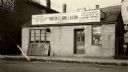
| Date: | 1906 |
|---|---|
| Description: | Bluff Street looking east. A sign painted on a building on the left reads: "Owl Cigar Now 5 CTS". |

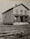
| Date: | 1900 |
|---|---|
| Description: | Bluff Street looking east. Pencil notation on this photograph reads: "House marked X is my home and is said to be built from stone from Fort Crawford. -A.C... |

| Date: | 1900 |
|---|---|
| Description: | Bluff street looking west. Posters are on a wall on the far right next to a building with an awning that reads: "Saloon". |
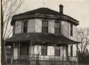
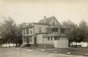
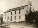
| Date: | 1920 |
|---|---|
| Description: | The Benedict Octagon House, built about 1843. |
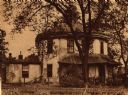
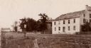
| Date: | 1940 |
|---|---|
| Description: | The Benedict House. Built by Dr. Alonzo Benedict and designed for two families. The original roof did not function correctly, so the builder put on a secon... |
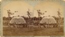
| Date: | 1890 |
|---|---|
| Description: | The Astor Company or Brisbois fur trading post. |
| Date: | 1920 |
|---|---|
| Description: | Astor fur trading building, The Northwest Fur Company, in 1808. This building was later used as a post office before the Civil War. |

| Date: | 1830 |
|---|---|
| Description: | Drawing of the Astor building. Caption reads: "Astor Building in 1830 Main Village Lot Prairie•du•Chien". |
| Date: | 1880 |
|---|---|
| Description: | Stereograph of an artesian well, located near the intersection of Wisconsin Street and South Minnesota Street (since renamed Wacouta). Construction was com... |
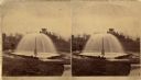
| Date: | 1876 |
|---|---|
| Description: | Stereograph of artesian well, located near the intersection of Wisconsin Street and South Minnesota Street (since renamed Wacouta). |
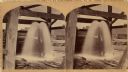
| Date: | 1875 |
|---|---|
| Description: | Stereograph of artesian well, apparently not the same one that was located near the intersection of Wisconsin Street and South Minnesota Street (since rena... |
| Date: | 1901 |
|---|---|
| Description: | View across railroad tracks towards the offices of the American Fur Company. The roof is damaged or deteriorating. |
| Date: | 1901 |
|---|---|
| Description: | View across railroad tracks towards the offices of the American Fur Company. The roof is damaged or deteriorated. |
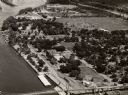
| Date: | 1958 |
|---|---|
| Description: | Aerial view of town. A bridge over the Mississippi River is in the foreground. |

| Date: | 1829 |
|---|---|
| Description: | Photoprint of Crawford County lead district map. |
| Date: | 1915 |
|---|---|
| Description: | French Cemetery. The Stone tombs are the graves of Joseph Rolette and his daughter, Elisabeth. |
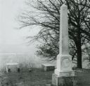
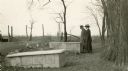
| Date: | |
|---|---|
| Description: | Graves of Michel Brisbois and (?) Tilmont on a bluff overlooking Prairie du Chien. |

| Date: | 1828 |
|---|---|
| Description: | Plat of the Private Claims at Prairie Du Chien. |
If you didn't find the material you searched for, our Library Reference Staff can help.
Call our reference desk at 608-264-6535 or email us at: