Filter: Categories of Wisconsin Historical Images
Filter: County of Crawford
Filter: Subject of human settlements
Filter: Subject of transportation
Filter: Categories of Wisconsin Historical Images
Filter: County of Crawford
Filter: Subject of human settlements
Filter: Subject of transportation
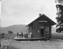
| Date: | 1916 |
|---|---|
| Description: | Exterior view of the Bell Center depot with five men posing on the platform. |
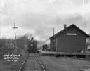
| Date: | 1912 |
|---|---|
| Description: | View down railroad tracks of a locomotive arriving at the Barnum Depot. |
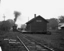
| Date: | |
|---|---|
| Description: | View from along railroad tracks of a train arriving at the depot. There is a child in the doorway of the depot, and a woman in the background is carrying a... |

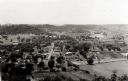
| Date: | 1905 |
|---|---|
| Description: | Elevated view of Soldiers' Grove with a bridge in the foreground. |

| Date: | 1870 |
|---|---|
| Description: | During the War of 1812, the only battle fought in Wisconsin was in Prairie du Chien, in 1814. Made fifty-six years later, this birds eye drawing depicts th... |
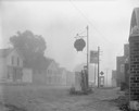
| Date: | 08 20 1961 |
|---|---|
| Description: | Street scene with a Shell gasoline station, the Kitty Korner Kafe, and a phone booth in early morning fog. |
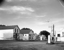
| Date: | 07 05 1965 |
|---|---|
| Description: | Street corner with gasoline station, 7-Up sign in front of restaurant next door, and several storefronts across the street. |

| Date: | 1884 |
|---|---|
| Description: | Bird's-eye view drawing of the grounds of Villa Louis, the estate of the fur trading Dousman family. After the death of H. Louis Dousman's mother in 1882, ... |
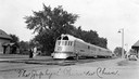
| Date: | |
|---|---|
| Description: | The diesel-powered Zephyr passenger train of the Chicago, Burlington & Quincy Railroad on the tracks at the depot. The Zephyr was introduced at the Chicago... |
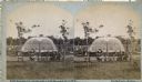
| Date: | 1880 |
|---|---|
| Description: | Stereograph of the Artesian Well near the intersection of Wisconsin and Minnesota (later renamed Wacouta) Streets. The following is printed on the backside... |
| Date: | 1900 |
|---|---|
| Description: | View from road of a partially covered bridge. Industrial buildings are near the entrance to the bridge on the left. |

| Date: | 1895 |
|---|---|
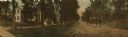
| Description: | View down road with the Bay State House on the left. Three houses and a barbershop also line the street. A lamppost is in the left foreground. The Mississ... |
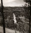
| Date: | 1950 |
|---|---|
| Description: | View from hill through two trees over a road with a guard fence, overlooking the town laid out along a main thoroughfare. The area is heavily forested, and... |
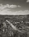
| Date: | |
|---|---|
| Description: | Elevated view of Gays Mills, with tree-covered hills in the background. |
| Date: | 1946 |
|---|---|
| Description: | Elevated view from hill of Gays Mills. Tree-covered hills are in the distance. |

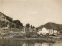
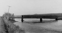
| Date: | 1908 |
|---|---|
| Description: | Elevated view of Wauzeka. A bridge over a river is in the background. |

| Date: | 09 1962 |
|---|---|
| Description: | The Mississippi River along Highway 35. |

| Date: | |
|---|---|
| Description: | 1. Stone Astor Fur Co. building built in 1808. 2. Voth Cottage, built in 1930. 3. Brisbois mansion, built 1808, by Michael Brisbois. 4. Site of Hudson Bay ... |
| Date: | 1900 |
|---|---|
| Description: | Dr. Jesse Rowley is driving the buggy on the road. Dr. Rowley was a co-founder of the Hospital for Rheumatic Diseases in Prairie du Chien, Wisconsin. Peopl... |
If you didn't find the material you searched for, our Library Reference Staff can help.
Call our reference desk at 608-264-6535 or email us at: