Filter: Categories of Wisconsin Historical Images
Filter: County of Crawford
Filter: Subject of human settlements
Filter: Subject of buildings
Filter: Categories of Wisconsin Historical Images
Filter: County of Crawford
Filter: Subject of human settlements
Filter: Subject of buildings

| Date: | 1905 |
|---|---|
| Description: | Elevated view of Soldiers' Grove with a bridge in the foreground. |

| Date: | 1836 |
|---|---|
| Description: | Woodcut of Prairie du Chien in 1836. Text at bottom reads: "Prairie du Chien in 1836. From an old cut." |
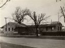
| Date: | 1900 |
|---|---|
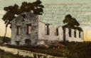
| Description: | A view of the ruins of the guardhouse used in 1883. Caption reads: "Ruins of Fort Crawford, Prairie du Chien, Wis." |
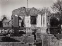
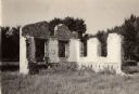
| Date: | 1910 |
|---|---|
| Description: | Fort Crawford ruins. Caption reads: "Ruins of Old Fort Crawford, Prairie-du-Chien, Wis." |
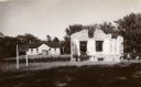
| Date: | 1925 |
|---|---|
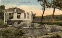
| Description: | Fort Crawford (the second site, showing ruins of the building of 1892-?). These are the ruins of the hospital. Caption reads: "The Ruins of Old Fort Crawfo... |
| Date: | 1875 |
|---|---|
| Description: | Stereograph of artesian well, apparently not the same one that was located near the intersection of Wisconsin Street and South Minnesota Street (since rena... |
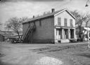
| Date: | |
|---|---|
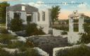
| Description: | The former Astor (American Fur Trading Company) post building, now a museum of local history and fur trading history. There is a sign reading: "The Riversi... |

| Date: | 1909 |
|---|---|
| Description: | View from the unpaved street of the Bank of Wauzeka, which is a small wood frame building with a large plate glass window. The sidewalk in front paved, and... |

| Date: | 1900 |
|---|---|
| Description: | This photocopy map shows proposed buildings and building use at Fort Crawford. |

| Date: | 1900 |
|---|---|
| Description: | This photocopy map shows marshes, woods, buildings, and selected features including islands, mounds, old Fort Crawford, and "new site for a fort in questio... |
| Date: | 1930 |
|---|---|
| Description: | This photocopy map includes cross section of buildings. |
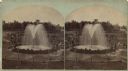
| Date: | |
|---|---|
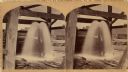
| Description: | Stereograph of Artesian well. A stone wall surrounds the well, with an observation area beyond. Groups of visitors are milling about and a drive with horse... |
| Date: | 1932 |
|---|---|
| Description: | Caption reads: Main Street, Soldiers Grove, Wis." The main street of a small town with businesses on each side. Automobiles and trucks are parked at the cu... |
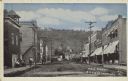
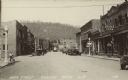
| Date: | 1921 |
|---|---|
| Description: | Text on front reads: "Main Street, Soldiers Grove, Wis. 1921." The main unpaved street of a small town with businesses on each side, including a barber, se... |
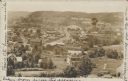
| Date: | 1910 |
|---|---|
| Description: | Text on front reads: "Bird's Eye View of Soldiers Grove." View of a small town surrounded by bluffs. The sender has written on both sides of the postcard. |

| Date: | 1910 |
|---|---|
| Description: | Text on front reads: "Kickapoo River Scene, Wauzeka, Wis." Elevated view of the shore of the Kickapoo River, with boats, piers and boathouses. A man in a r... |
If you didn't find the material you searched for, our Library Reference Staff can help.
Call our reference desk at 608-264-6535 or email us at: