 Filter: Categories of Wisconsin Historical Images
Filter: County of Crawford
Filter: Community of Wauzeka
Filter: Categories of Wisconsin Historical Images
Filter: County of Crawford
Filter: Community of Wauzeka
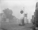
| Date: | 08 20 1961 |
|---|---|
| Description: | Street scene with a Shell gasoline station, the Kitty Korner Kafe, and a phone booth in early morning fog. |
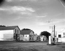
| Date: | 07 05 1965 |
|---|---|
| Description: | Street corner with gasoline station, 7-Up sign in front of restaurant next door, and several storefronts across the street. |
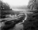
| Date: | 08 13 1961 |
|---|---|
| Description: | A Wisconsin River swamp. The swampy area is framed by trees with more trees in the background hidden by fog. |

| Date: | 1908 |
|---|---|
| Description: | Elevated view of Wauzeka. A bridge over a river is in the background. |

| Date: | 08 20 1961 |
|---|---|
| Description: | Fog lifts from a cornfield and low hills along Highway 131. |

| Date: | 08 20 1961 |
|---|---|
| Description: | A tree-lined view of the Wisconsin River. The photograph was taken from an elevated area near a highway. |

| Date: | 08 20 1961 |
|---|---|
| Description: | Three large rows of stacked logs are piled outside a small factory building. |
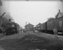
| Date: | |
|---|---|
| Description: | View towards railroad depot with trains on railroad tracks on the left and right. In the foreground is a pile of gravel. There is a group of people on and ... |

| Date: | 1909 |
|---|---|
| Description: | View from the unpaved street of the Bank of Wauzeka, which is a small wood frame building with a large plate glass window. The sidewalk in front paved, and... |

| Date: | 1930 |
|---|---|
| Description: | View across road or path of St. Paul's Evangelical Lutheran Church, which is a wood frame building with a double door entrance with transom windows above, ... |

| Date: | 1930 |
|---|---|
| Description: | View up hill of the public school, which is a two-story wood frame building with a belfry in the center of the roof. Stairs lead to the arched entrance, an... |

| Date: | 1890 |
|---|---|
| Description: | This is a plat map of "Wauzeeka" drawn in pencil. The map shows numbered lots, labeled streets, the Kickapoo River, and railroads. The map reads: "Laid out... |

| Date: | 09 10 1961 |
|---|---|
| Description: | Kickapoo Valley landscape with a dead white tree in the vicinity of Highway 131. |

| Date: | 1856 |
|---|---|
| Description: | This map shows lot and block numbers, streets, a mill, the Milwaukee and Mississippi Railroad, the train depot, and the Kickapoo River. Included in the low... |

| Date: | 1856 |
|---|---|
| Description: | This map is ink and color on paper and mounted on cloth. The map shows lot and block numbers, streets, a railroad, and the Kickapoo River. Some lots are c... |

| Date: | 08 20 1961 |
|---|---|
| Description: | Pond with lily pads at the intersection of Highways 131 and 60 on a foggy morning. In the background are hills shrouded in mist. |

| Date: | 03 19 1913 |
|---|---|
| Description: | Text on front reads: "Depot and Train, Wauzeka, Wis." View towards a train depot between two sets of tracks, with a locomotive on the tracks on the left, a... |

| Date: | 1910 |
|---|---|
| Description: | Text on front reads: "Kickapoo River Scene, Wauzeka, Wis." Elevated view of the shore of the Kickapoo River, with boats, piers and boathouses. A man in a r... |
If you didn't find the material you searched for, our Library Reference Staff can help.
Call our reference desk at 608-264-6535 or email us at: