 Filter: Categories of Wisconsin Historical Images
Filter: County of Columbia
Filter: Year of 1900-1999
Filter: Subject of lakes
Filter: Categories of Wisconsin Historical Images
Filter: County of Columbia
Filter: Year of 1900-1999
Filter: Subject of lakes

| Date: | 1936 |
|---|---|
| Description: | This map is red and black ink on tracing cloth and is oriented with north to the upper left. This hand-drawn map shows a central portion of the military ro... |
| Date: | 1959 |
|---|---|
| Description: | The Kilbourn Hydroelectric Plant of the Wisconsin Power and Light Company. |
| Date: | 1965 |
|---|---|
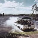
| Description: | Amphibious vehicle known as a Duck splashes into Lake Delton as it carries passengers on a tour of the Wisconsin Dells. |

| Date: | 1965 |
|---|---|
| Description: | Elevated view of pyramid of water skiers in Tommy Bartlett's show on Lake Delton. The woman on top of the pyramid holds a red flag. |
| Date: | 07 24 1966 |
|---|---|
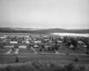
| Description: | Elevated view of small town. A Lake Wisconsin is visible beyond the town limits. |
| Date: | 06 27 1910 |
|---|---|
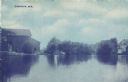
| Description: | Colorized postcard of Tarrant Lake with buildings along the shoreline. Caption reads: "Cambria, Wis." |

| Date: | 1930 |
|---|---|
| Description: | Hand-colored image of two swimmers sitting on a pier with their legs in the water at a camp in West Point sponsored by Neighborhood House. Several other sw... |
| Date: | 1942 |
|---|---|
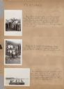
| Description: | Page from a scrapbook kept by Neighborhood House, with highlights of the boys summer camp at Camp America Williams: "backwards" day, with a line of boys dr... |

| Date: | 1935 |
|---|---|
| Description: | This 1935 map shows the Wisconsin River from a point approximately 4 miles south of the city of Wisconsin Dells north to Duck Creek in Adams County. Sectio... |

| Date: | 1905 |
|---|---|
| Description: | Shows railroads, roads, post offices, creeks, lakes, and cities. Includes chart of deposits and total resources from the years 1890 to 1905. "First Natio... |
| Date: | 1926 |
|---|---|
| Description: | Lake Wisconsin at Summerville Park. Boathouses, docks and fishing boats are along the shoreline. |
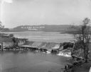
| Date: | 1911 |
|---|---|
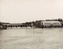
| Description: | Elevated view of the Mill Dam at the convergence of Lake Wisconsin and the Wisconsin River. |
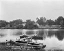
| Date: | 1927 |
|---|---|
| Description: | View from shoreline of a pair of men fishing in a lake. Another rowboat is tied at a pier in the foreground. On the far shoreline are cottages and trees. |
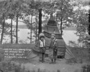
| Date: | 1927 |
|---|---|
| Description: | A Native American boy and girl pose standing in front of a tipi on a hill by a lake. The tipi is covered with a fringed blanket. |

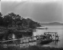
| Date: | 1927 |
|---|---|
| Description: | Four people, two men and two women, stand on a pier near an excursion boat on Lake Delton. A sign with flags is on top of the boat and reads: "Lake and Riv... |

| Date: | 1926 |
|---|---|
| Description: | Men and boys fishing at Jordan Lake. One man is standing next to a boat pulled up at the shore and is holding up his catch of the day. There are cattails a... |

| Date: | 1928 |
|---|---|
| Description: | View from hill of Jordan Lake. Two people are fishing in a rowboat below, and the wooded far shoreline is in the distance. |

| Date: | 1920 |
|---|---|
| Description: | This street map was likely given out by the Rebholz Company: Clothiers and Furnishers. The map shows labeled streets, train tracks, Silver Lake, Mud Lake, ... |

| Date: | 1900 |
|---|---|
| Description: | This map shows landownership, churches, schools, farm houses, wagon roads, railroads, and townships and includes businesses advertisements, tables of stati... |

| Date: | 1900 |
|---|---|
| Description: | This manuscript map shows outline of Fort Winnebago reserve land, Fort Winnebago, claim of A. Grignon, and Indian boundaries. The Fox River and Swan Lake a... |
If you didn't find the material you searched for, our Library Reference Staff can help.
Call our reference desk at 608-264-6535 or email us at: