Filter: Categories of Wisconsin Historical Images
Filter: County of Columbia
Filter: Year of 1800-1899
Filter: Year of 1850-1859
Filter: Categories of Wisconsin Historical Images
Filter: County of Columbia
Filter: Year of 1800-1899
Filter: Year of 1850-1859
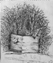
| Date: | 1850 |
|---|---|
| Description: | Black and white ink drawing of an old wooden well. |
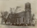
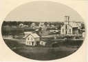
| Date: | 1855 |
|---|---|
| Description: | Church built in 1855 for First Presbyterian congregation. In May 1892, fire destroyed the interior. The congregation sold the damaged building to the Bapti... |

| Date: | 1855 |
|---|---|
| Description: | Fox-Wisconsin portage and canal map, when the canal was not yet built. From a map in the office of the city clerk at Portage. "The old trail, the location ... |

| Date: | 1854 |
|---|---|
| Description: | This map is ink and watercolor on tracing cloth and shows lot and block numbers, streets, a park, and depots. Some lots are colored red or blue and some in... |
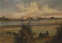
| Date: | 1856 |
|---|---|
| Description: | "After painting a number of Fox River scenes, "the artists continued their way to Fond du Lac, at the south end of Lake Winnebago, where they found some mo... |

| Date: | 1854 |
|---|---|
| Description: | Register of the Deed Office filed by the land surveyor and lawyer Alfred Topliff. The document includes detailed listings of city blocks. In the right hand... |

| Date: | 1856 |
|---|---|
| Description: | This map shows plat of town, local streets, railroads, projected railroads, residential buildings, mills, and part of the Crawfish River. The map includes ... |

| Date: | 1856 |
|---|---|
| Description: | This map is ink and pencil on paper and shows plat of the town, local streets, and blocks and lots by number. The map includes explanatory text. |

| Date: | 1856 |
|---|---|
| Description: | This plat shows block and lot numbers and land reserved for a railroad and passenger depot. The map includes certifications and registration. Kilbourn City... |

| Date: | 1855 |
|---|---|
| Description: | This map shows landownership, lot and block numbers, streets, a canal, bridges, Fort Winnebago, the Wisconsin River, and the Fox River. Relief is shown by ... |
If you didn't find the material you searched for, our Library Reference Staff can help.
Call our reference desk at 608-264-6535 or email us at: