 Filter: Categories of Wisconsin Historical Images
Filter: County of Columbia
Filter: Type of Map or Atlas
Filter: Categories of Wisconsin Historical Images
Filter: County of Columbia
Filter: Type of Map or Atlas

| Date: | 1856 |
|---|---|
| Description: | This map shows plat of town, local streets, railroads, projected railroads, residential buildings, mills, and part of the Crawfish River. The map includes ... |

| Date: | 1856 |
|---|---|
| Description: | This map is ink and pencil on paper and shows plat of the town, local streets, and blocks and lots by number. The map includes explanatory text. |
| Date: | 1836 |
|---|---|
| Description: | This map shows proposed lot and block numbers for a paper city located in township 10 north, range 7 east, Wisconsin Territory, now the Town of West Point,... |

| Date: | 1856 |
|---|---|
| Description: | This plat shows block and lot numbers and land reserved for a railroad and passenger depot. The map includes certifications and registration. Kilbourn City... |

| Date: | 1800 |
|---|---|
| Description: | This map shows the land claim owned by the Portage Canal Company and includes an index of landownership and landmarks. The Wisconsin and Portage River, the... |

| Date: | 1800 |
|---|---|
| Description: | This map is pencil on tracing paper and shows marshes, the Wisconsin River, Indian trails, and Indian boundary line. The upper left corner reads: "Let sect... |

| Date: | 1920 |
|---|---|
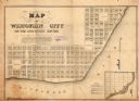
| Description: | This street map was likely given out by the Rebholz Company: Clothiers and Furnishers. The map shows labeled streets, train tracks, Silver Lake, Mud Lake, ... |
| Date: | 1830 |
|---|---|
| Description: | This plat map is pen-and-ink on tracing paper and shows a paper city planned in the late 1830's located on the shore of Swan Lake, Columbia County, Wiscons... |

| Date: | 1956 |
|---|---|
| Description: | This map shows Lake Wisconsin, roads, highways, parks, resort areas, camps, gardens, and Wisconsin State experimental game and fur farm. The back of the ma... |

| Date: | 11 1836 |
|---|---|
| Description: | This map is pen-and-ink on paper and is a plat of a paper city on the Wisconsin River, in what is now the Town of Dekorra. The map shows lot and block numb... |

| Date: | |
|---|---|
| Description: | This plat map shows lots and block numbers of a paper city located on the Wisconsin River and Hasting’s Creek, in what is now the Town of West Point, Colum... |

| Date: | 1836 |
|---|---|
| Description: | This map shows lot and block numbers, streets, a proposed canal basin, Fort Winnebago, and the Wisconsin and Fox Rivers. Relief is shown by hachures and no... |

| Date: | 1855 |
|---|---|
| Description: | This map shows landownership, lot and block numbers, streets, a canal, bridges, Fort Winnebago, the Wisconsin River, and the Fox River. Relief is shown by ... |

| Date: | 11 21 1950 |
|---|---|
| Description: | This map shows agricultural, residence, business, and industrial districts as well as lot and block numbers. |

| Date: | 1960 |
|---|---|
| Description: | This map includes a sheet index showing streets, proposed streets, the high school, and railroad. |

| Date: | 1914 |
|---|---|
| Description: | This photostat map shows Fort Winnebago around 1931, land to be reserved for military purposes, roads to Fort Howard and Fort Crawford, "private property" ... |

| Date: | 1900 |
|---|---|
| Description: | This map shows landownership, churches, schools, farm houses, wagon roads, railroads, and townships and includes businesses advertisements, tables of stati... |
| Date: | 1900 |
|---|---|
| Description: | This map shows lots, public squares, landing, streets, and promenade of a paper city on a site now in the Town of West Point, Columbia County. The Wisconsi... |

| Date: | 1900 |
|---|---|
| Description: | This manuscript map shows outline of Fort Winnebago reserve land, Fort Winnebago, claim of A. Grignon, and Indian boundaries. The Fox River and Swan Lake a... |

| Date: | 1900 |
|---|---|
| Description: | This photocopy plat map of Pauquette, now Poynette, shows streets and lot numbers. |
If you didn't find the material you searched for, our Library Reference Staff can help.
Call our reference desk at 608-264-6535 or email us at: