 Filter: Categories of Wisconsin Historical Images
Filter: County of Clark
Filter: Subject of cities and towns
Filter: Categories of Wisconsin Historical Images
Filter: County of Clark
Filter: Subject of cities and towns
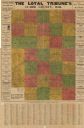
| Date: | 1914 |
|---|---|
| Description: | This early-20th century map of Clark County, Wisconsin, shows the township and range grid, towns, sections, cities and villages, property owners and acreag... |

| Date: | 1936 |
|---|---|
| Description: | This 1936 map of Clark County, Wisconsin, shows the township and range grid, sections, cities and town, and lakes and streams in the county. It lacks the k... |

| Date: | 1933 |
|---|---|
| Description: | Blue line copy on paper with manuscript additions in color. Shows boundaries of zoned areas, Wisconsin historical lands in zoned areas, county lands outsid... |
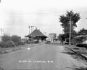
| Date: | 1927 |
|---|---|
| Description: | A street scene with the train depot on the left. An automobile parked on the street side. A seed store on the next block with someone entering it. There is... |
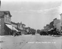
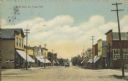
| Date: | 1927 |
|---|---|
| Description: | A view of downtown Thorp. Lampposts lining the street on both sides. Cars parked at the curbs on both sides. A couple cars driving away down the street. On... |
| Date: | 1927 |
|---|---|
| Description: | View uphill towards the central business district. Commercial buildings on the left include a service station and Hotel Thorp. On the right are commercial ... |
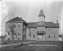
| Date: | 1927 |
|---|---|
| Description: | A view of the public school, a large two-story brick building with a belfry. Young trees lining the pathway to the entrance. |
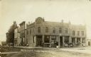
| Date: | 1911 |
|---|---|
| Description: | View from unpaved street towards the Alb. R. Schwahn building on a corner. There are pedestrians on the sidewalk, and horse-drawn vehicles are parked near ... |
| Date: | 1905 |
|---|---|
| Description: | This blueprint map shows land parcels and roads. The map includes manuscript annotations in what appears to be red pencil. |

| Date: | 1908 |
|---|---|
| Description: | View down unpaved street in Chili towards commercial buildings, with horses and wagons parked on the street. Railroad tracks are in the foreground. |

| Date: | 1910 |
|---|---|
| Description: | This set of manuscript blueprint maps show block and lot numbers, railroads, and some landownership, including lands and buildings of J.S. Owen Lumber Co. ... |

| Date: | |
|---|---|
| Description: | Elevated view of the Village of Humbird. Caption reads: "BirdeEye, Humbird, Wis." |
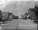
| Date: | 08 12 1912 |
|---|---|
| Description: | Text on front reads: "North Main St., Thorp, Wis." Storefronts with awnings line an unpaved street with paved sidewalks, a horse-drawn wagon travels down t... |
| Date: | 1921 |
|---|---|
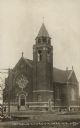
| Description: | Caption reads: "Catholic Church, Thorp, Wis." St. Bernard Catholic Church is a brick church built in 1914. In 1974 the parish was combined with St. Hedwig ... |
| Date: | 04 29 1914 |
|---|---|
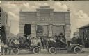
| Description: | Caption reads: "State Bank. Unity, Wis." A large group of children and adults pose in front of the Unity State Bank, some seated in two automobiles. Signs ... |

| Date: | 09 08 1916 |
|---|---|
| Description: | Text on front reads: "Greetings, Unity, Wis." A collage of 4 postcards with views of parades and celebrations in the downtown area. |

| Date: | 10 13 1912 |
|---|---|
| Description: | Caption reads: "Hotel Nelson, Unity, Wis." A two-story clapboard dwelling with two porches. There are trees in front and to the right. |
| Date: | 06 15 1908 |
|---|---|
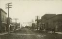
| Description: | Caption reads: "Street Scene Abbottsford [sic], Wisconsin". A group of mainly children are standing on the boardwalk along an unpaved street lined w... |
If you didn't find the material you searched for, our Library Reference Staff can help.
Call our reference desk at 608-264-6535 or email us at: