Filter: Categories of Wisconsin Historical Images
Filter: County of Chippewa
Filter: Year of 1900-1999
Filter: Year of 1930-1939
Filter: Categories of Wisconsin Historical Images
Filter: County of Chippewa
Filter: Year of 1900-1999
Filter: Year of 1930-1939
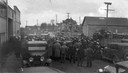
| Date: | 1932 |
|---|---|
| Description: | Crowd gathered for the milk strike at Stanley. |
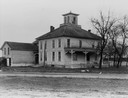
| Date: | 1935 |
|---|---|
| Description: | An old house in a rural area, with some broken windows, and a road in the foreground. |

| Date: | 1930 |
|---|---|
| Description: | This road map of Chippewa County, Wisconsin, dates to around 1930. It shows the township and range grid, towns, sections, cities and villages, railroads, l... |
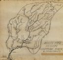
| Date: | 1931 |
|---|---|
| Description: | This manuscript map shows the Chippewa River watershed, including the Red Cedar or Menomonie River, Flambeau or Manitowish River, Jump River, Eau Claire Ri... |

| Date: | 1938 |
|---|---|
| Description: | Exterior view of front entrance of the Hospital building at The Northern Wisconsin Colony and Training School. Climbing vines cover the exterior wall of th... |
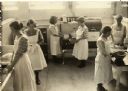
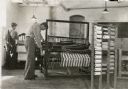
| Date: | 1930 |
|---|---|
| Description: | Slightly elevated view of six women wearing aprons learning domestic skills in a kitchen classroom. Two women on the left stand at a sink washing dishes, t... |

| Date: | 08 09 1936 |
|---|---|
| Description: | Outdoor group portrait of fourteen people who make up the Governor's Citizens Committee on Public Welfare. They are posed front of a building at the Northe... |
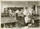
| Date: | 1938 |
|---|---|
| Description: | Eight men working on various woodworking projects in a classroom setting at Northern Wisconsin Center for the Developmentally Disabled. |
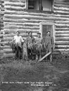
| Date: | 1930 |
|---|---|
| Description: | Group portrait of four men standing behind a row of fish on a stringer. Two large muskies are in the center. The men are standing in front of a two-story l... |

| Date: | 1938 |
|---|---|
| Description: | This map shows plat of town, land ownership by name, city limits, section boundaries, wards, local roads, railroads, parks, fairgrounds, cemeteries, locati... |

| Date: | 1936 |
|---|---|
| Description: | View from street towards the St. Joseph's Hospital. In the center is a two level open porch, with two people on the second level. A 1930s automobile is par... |
If you didn't find the material you searched for, our Library Reference Staff can help.
Call our reference desk at 608-264-6535 or email us at: