Filter: Categories of Wisconsin Historical Images
Filter: County of Chippewa
Filter: Year of 1900-1999
Filter: Categories of Wisconsin Historical Images
Filter: County of Chippewa
Filter: Year of 1900-1999
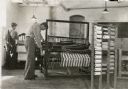
| Date: | 1938 |
|---|---|
| Description: | Eight men working on various woodworking projects in a classroom setting at Northern Wisconsin Center for the Developmentally Disabled. |
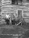
| Date: | 1930 |
|---|---|
| Description: | Group portrait of four men standing behind a row of fish on a stringer. Two large muskies are in the center. The men are standing in front of a two-story l... |
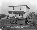
| Date: | 08 07 1924 |
|---|---|
| Description: | An overturned car sits among broken pieces of wood, including a broken chair, in a field. An arrow and the words: "Richard Sikora Killed Here" points to th... |
| Date: | 08 07 1924 |
|---|---|
| Description: | The aftermath of a killer tornado, including an arrow and caption that reads: "William Berg Killed Here." In the background near the farmhouse are a group ... |
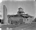
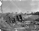
| Date: | 08 07 1924 |
|---|---|
| Description: | View across railroad tracks of the canning factory in the aftermath of a tornado. The top of the brick structure and the smokestack has been blown off. Pil... |
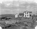
| Date: | 08 07 1924 |
|---|---|
| Description: | View across yard of a storm-damaged farmhouse. In the foreground is an overturned automobile. The windows of the house have been blown out and the roof has... |
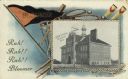
| Date: | 1908 |
|---|---|
| Description: | Photographic postcard featuring an illustration of the high school, bordered by a pennant, a baseball bat, golf clubs, rowing oars and tennis rackets. Capt... |
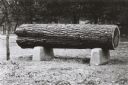
| Date: | 1908 |
|---|---|
| Description: | Cut sample pine log mounted as an exhibit in Irvine Park. |

| Date: | 1951 |
|---|---|
| Description: | This map of Chippewa Falls shows the city of Chippewa River, city limits, roads, highways, fair grounds, and parks. |

| Date: | 1920 |
|---|---|
| Description: | Rear view of the first parsonage occupied by the Reverend Mr. Row. |

| Date: | 1920 |
|---|---|
| Description: | View of front porch of the first parsonage occupied by the Reverend Mr. Row. |

| Date: | 1938 |
|---|---|
| Description: | This map shows plat of town, land ownership by name, city limits, section boundaries, wards, local roads, railroads, parks, fairgrounds, cemeteries, locati... |

| Date: | 1975 |
|---|---|
| Description: | This standard U.S.G.S. topographic map was annotated by civil engineer and railroad historian James P. Kaysen to show the location of existing and defunct ... |

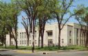
| Date: | 1916 |
|---|---|
| Description: | Hand-colored postcard view from across street towards the Chippewa Falls High School on North Bridge Street. Caption reads: "High School, Chippewa Falls, W... |

| Date: | 1910 |
|---|---|
| Description: | Hand-colored postcard of McDonell Memorial High School. Caption reads: "McDonell Memorial High School, Chippewa Falls, Wis." |

| Date: | 1910 |
|---|---|
| Description: | Hand-colored postcard view looking up a unpaved road and sidewalk at McDonell Memorial High School and Notre Dame church with the nuns' convent in the back... |
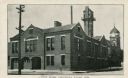
| Date: | 1920 |
|---|---|
| Description: | View from street of Chippewa Falls city hall. On the left are garage doors for fire engine storage, and a watch tower is at upper right. Another building ... |
| Date: | 1950 |
|---|---|
| Description: | Color postcard of new County Court House, a two-story white granite building with elm trees in front. |

| Date: | 1915 |
|---|---|
| Description: | Color postcard of Chippewa County Court House at Chippewa Falls. Caption reads: "Chippewa County Court House, Chippewa Falls, Wis." |
If you didn't find the material you searched for, our Library Reference Staff can help.
Call our reference desk at 608-264-6535 or email us at: