 Filter: Categories of Wisconsin Historical Images
Filter: County of Chippewa
Filter: Year of 1900-1999
Filter: Year of 1910-1919
Filter: Categories of Wisconsin Historical Images
Filter: County of Chippewa
Filter: Year of 1900-1999
Filter: Year of 1910-1919
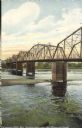
| Date: | 1910 |
|---|---|
| Description: | A colorized view from shoreline of the steel beam bridge, with five sections and five bridge pylons. The bridge was downstream from the rapids on Main stre... |
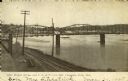
| Date: | 1910 |
|---|---|
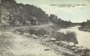
| Description: | Elevated view looking east and upstream from the shoreline towards the wide Chippewa River. The water level is nearly up to the railroad tracks in the fore... |
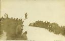
| Date: | 1910 |
|---|---|
| Description: | View looking up towards a ski jumper airborne over the top edge of a hill as a large crowd is looking on from the sides. The top of the ski jump scaffold i... |
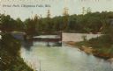
| Date: | 1910 |
|---|---|
| Description: | Colorized view of a bridge crossing Duncan Creek in Irvine Park with trees and river bend in background. Caption reads: "Irvine Park, Chippewa Falls, Wis." |
| Date: | 1910 |
|---|---|
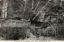
| Description: | Rock outcroppings with birch trees and a long staircase climbing a hill in Irvine Park. Caption reads: "A Cool Retreat and Springs, Irvine Park, Chippewa F... |
| Date: | 1910 |
|---|---|
| Description: | View down tree-lined "lovers' lane" on a hill along a stone wall and rock outcroppings in Irvine Park. Caption reads: "Lovers' Lane, Irvine Park, Chippewa ... |
| Date: | 1910 |
|---|---|
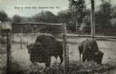
| Description: | View of two bison grazing on weeds behind a tall wire fence in Irvine Park. Caption reads: "Bison at Irvine Park, Chippewa Falls, Wis." |
| Date: | 1910 |
|---|---|
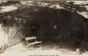
| Description: | Sunlit opening of a large carved out man-made cave with a park bench in the foreground in Irvine Park. The figure of a woman in the cave is obscured by sha... |
| Date: | 1910 |
|---|---|
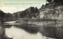
| Description: | View of a bend in Duncan Creek with a bridge, trees, a quarried rock face and road in Irvine Park (probably the "Bear Cage Road"). Caption reads: "Bridge a... |
| Date: | 1910 |
|---|---|
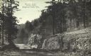
| Description: | A curving, rutted dirt road between a rock wall at Duncan Creek in Irvine Park (probably the "Bear Cage Road"). Caption reads: "Driveway at Duncan Creek in... |

| Date: | 1910 |
|---|---|
| Description: | Colorized view of a rutted dirt road next to a rock face in Irvine Park. Caption reads: "A Rocky Scene In Irvine Park, Chippewa Falls, Wis." |

| Date: | 1910 |
|---|---|
| Description: | Colorized image of entrance to Irvine Park showing concrete paved road and driveway, trees, flowers and electric light fixtures. On the left side is an ope... |
| Date: | 1910 |
|---|---|
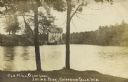
| Description: | View from opposite shoreline through trees toward the Glen Loch dam and mill in Irvine Park. Caption reads: "Old Mill, Glen Loch, Irvine Park, Chippewa Fal... |
| Date: | 1910 |
|---|---|
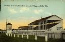
| Description: | Colorized view of the grandstand at the Northern Wisconsin State Fair Grounds. Caption reads: "Northern Wisconsin State Fair Grounds, Chippewa Falls, Wis." |
| Date: | 1910 |
|---|---|
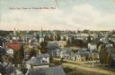
| Description: | Hand-colored elevated view of houses, churches, commercial buildings, unpaved road, sidewalks and fences in central Chippewa Falls. Caption reads: "Bird's ... |
| Date: | 1910 |
|---|---|
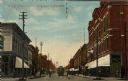
| Description: | Colorized view of Bridge Street, looking north from Spring Street intersection, in the central business district. The view includes stores, some with canva... |

| Date: | 1912 |
|---|---|
| Description: | This blueprint manuscript map shows landownership, mills, railroad, churches, public buildings, the old cemetery, and the Chippewa River and Reservoir. The... |
If you didn't find the material you searched for, our Library Reference Staff can help.
Call our reference desk at 608-264-6535 or email us at:


