Filter: Categories of Wisconsin Historical Images
Filter: County of Chippewa
Filter: Year of 1900-1999
Filter: Subject of roads
Filter: Categories of Wisconsin Historical Images
Filter: County of Chippewa
Filter: Year of 1900-1999
Filter: Subject of roads
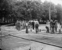
| Date: | 1900 |
|---|---|
| Description: | Horse-drawn wagons, including a water wagon, stand on a street next to a broad sidewalk in a commercial district. The storefronts of P.L. McQuillan and Con... |
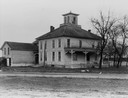
| Date: | 1935 |
|---|---|
| Description: | An old house in a rural area, with some broken windows, and a road in the foreground. |
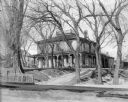
| Date: | 1900 |
|---|---|
| Description: | View from road of exterior of house on the H.S. Allen homestead. The house has a widow's walk and a wrap-around porch. There are many large trees on the pr... |
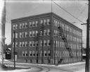
| Date: | 1900 |
|---|---|
| Description: | The square, four-story brick Chippewa Shoe Company building, located at the intersection of Bay Street and River Street looking North. There is a fire esca... |
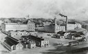
| Date: | 1910 |
|---|---|
| Description: | An engraving of an elevated view of the Leinenkugel brewery, est. 1867, located at 5 Jefferson Avenue. |

| Date: | 1900 |
|---|---|
| Description: | F.G. and C.A. Stanley Manufacturing Plant. There is a plank sidewalk in the foreground. |

| Date: | 1903 |
|---|---|
| Description: | Several buildings in the complex of the F.G. and C.A. Stanley Manufacturing Plant. The largest building is labeled "F.G. and C.A. Stanley." A smaller build... |
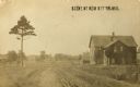
| Date: | 1905 |
|---|---|
| Description: | View down dirt road with a tree on the left, and a building (house?) on the right. More buildings are further down the road. Caption reads: "Scene at New A... |

| Date: | 05 1921 |
|---|---|
| Description: | A man drives an International Model G-61 truck on a rural road with power lines. The truck was operated by G.E. Hutchinson's Standard Oil Company business. |
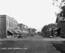
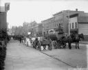
| Date: | 1929 |
|---|---|
| Description: | View down retail street. Cars are parked along the curbs. The stores include: Victrola's dealer, a cafe, a recreation parlor, a restaurant, a clothing stor... |
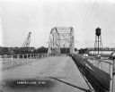
| Date: | 1927 |
|---|---|
| Description: | View down middle of metal bridge across the Cornell Flowage. Across the lake, there is the pulpwood stacker on the left and a water tower on the right near... |

| Date: | 1900 |
|---|---|
| Description: | This early 20th century map of Chippewa County, Wisconsin, shows the township and range grid, towns, sections, cities and villages, roads, railroads, schoo... |

| Date: | 1918 |
|---|---|
| Description: | This 1918 map of Chippewa County, Wisconsin, shows the township and range grid, towns, sections, cities and villages, rural residences, churches, schools, ... |

| Date: | 1930 |
|---|---|
| Description: | This road map of Chippewa County, Wisconsin, dates to around 1930. It shows the township and range grid, towns, sections, cities and villages, railroads, l... |

| Date: | 1951 |
|---|---|
| Description: | This map of Chippewa Falls shows the city of Chippewa River, city limits, roads, highways, fair grounds, and parks. |

| Date: | 1938 |
|---|---|
| Description: | This map shows plat of town, land ownership by name, city limits, section boundaries, wards, local roads, railroads, parks, fairgrounds, cemeteries, locati... |

| Date: | 1910 |
|---|---|
| Description: | Hand-colored postcard view looking up a unpaved road and sidewalk at McDonell Memorial High School and Notre Dame church with the nuns' convent in the back... |
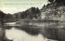
| Date: | 1910 |
|---|---|
| Description: | View down tree-lined "lovers' lane" on a hill along a stone wall and rock outcroppings in Irvine Park. Caption reads: "Lovers' Lane, Irvine Park, Chippewa ... |
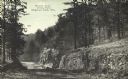
| Date: | 1910 |
|---|---|
| Description: | View of a bend in Duncan Creek with a bridge, trees, a quarried rock face and road in Irvine Park (probably the "Bear Cage Road"). Caption reads: "Bridge a... |
If you didn't find the material you searched for, our Library Reference Staff can help.
Call our reference desk at 608-264-6535 or email us at: