Filter: Categories of Wisconsin Historical Images
Filter: County of Chippewa
Filter: Year of 1900-1999
Filter: Subject of cities and towns
Filter: Categories of Wisconsin Historical Images
Filter: County of Chippewa
Filter: Year of 1900-1999
Filter: Subject of cities and towns
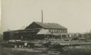
| Date: | 05 03 1908 |
|---|---|
| Description: | Photographic postcard of the Filtz and Sons Box Factory. Logs are stacked in the foreground. Caption reads: "Filtz and Sons Box Factory, Cadott, Wisconsin.... |

| Date: | 1926 |
|---|---|
| Description: | A busy street scene. Cars are parked at the curbs on either side of the street. Two women walk on the sidewalk. An American flag flies from the top of a bu... |
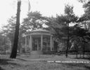
| Date: | 1926 |
|---|---|
| Description: | A gazebo dedicated to solders and sailors in Irvine Park. A flagpole and benches are in front of the gazebo. |

| Date: | 1926 |
|---|---|
| Description: | Exterior of the Hotel Northern. The hotel has a Western Union and drugstore on the street level. An American flag flies from the top of the building. |

| Date: | 1926 |
|---|---|
| Description: | Exterior of the Edward Rutledge Charity. There is a sign for the tourist camp and Irvine Park on the lamppost. |
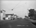
| Date: | 1927 |
|---|---|
| Description: | View down street of trucks and cars parked at an angle along the curb in a commercial strip through town. The buildings on the left have signs, including t... |
| Date: | 1927 |
|---|---|
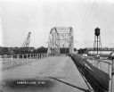
| Description: | View down middle of metal bridge across the Cornell Flowage. Across the lake, there is the pulpwood stacker on the left and a water tower on the right near... |
| Date: | 1927 |
|---|---|
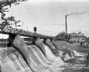
| Description: | View across lower section of dam at Cornell Wood Products Company. In the background are factory buildings, a tall smokestack, and a water tower. |
| Date: | 1927 |
|---|---|
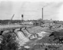
| Description: | Elevated view over dam of the site of the Cornell Wood Products Company. On the opposite shoreline is a pulpwood stacker, tall smokestack, water tower, and... |
| Date: | 1924 |
|---|---|
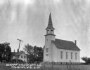
| Description: | Exterior of the German English Lutheran Church. The church has a gable roof and a steeple with a bell. In the foreground is a fence and field, and in the b... |

| Date: | 1900 |
|---|---|
| Description: | This early 20th century map of Chippewa County, Wisconsin, shows the township and range grid, towns, sections, cities and villages, roads, railroads, schoo... |

| Date: | 1918 |
|---|---|
| Description: | This 1918 map of Chippewa County, Wisconsin, shows the township and range grid, towns, sections, cities and villages, rural residences, churches, schools, ... |

| Date: | 1930 |
|---|---|
| Description: | This road map of Chippewa County, Wisconsin, dates to around 1930. It shows the township and range grid, towns, sections, cities and villages, railroads, l... |

| Date: | 1902 |
|---|---|
| Description: | This 1902 map of Chippewa County, Wisconsin, shows the township and range grid, towns, sections, cities, villages and post offices, land ownership and acre... |
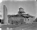
| Date: | 08 07 1924 |
|---|---|
| Description: | View across railroad tracks of the canning factory in the aftermath of a tornado. The top of the brick structure and the smokestack has been blown off. Pil... |
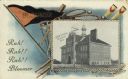
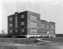
| Date: | 1908 |
|---|---|
| Description: | Photographic postcard featuring an illustration of the high school, bordered by a pennant, a baseball bat, golf clubs, rowing oars and tennis rackets. Capt... |

| Date: | 1951 |
|---|---|
| Description: | This map of Chippewa Falls shows the city of Chippewa River, city limits, roads, highways, fair grounds, and parks. |

| Date: | 1938 |
|---|---|
| Description: | This map shows plat of town, land ownership by name, city limits, section boundaries, wards, local roads, railroads, parks, fairgrounds, cemeteries, locati... |

| Date: | 1975 |
|---|---|
| Description: | This standard U.S.G.S. topographic map was annotated by civil engineer and railroad historian James P. Kaysen to show the location of existing and defunct ... |
If you didn't find the material you searched for, our Library Reference Staff can help.
Call our reference desk at 608-264-6535 or email us at: