 Filter: Categories of Wisconsin Historical Images
Filter: County of Chippewa
Filter: Year of 1900-1999
Filter: Type of Map or Atlas
Filter: Year of 1930-1939
Filter: Categories of Wisconsin Historical Images
Filter: County of Chippewa
Filter: Year of 1900-1999
Filter: Type of Map or Atlas
Filter: Year of 1930-1939

| Date: | 1930 |
|---|---|
| Description: | This road map of Chippewa County, Wisconsin, dates to around 1930. It shows the township and range grid, towns, sections, cities and villages, railroads, l... |
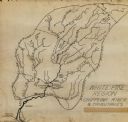
| Date: | 1931 |
|---|---|
| Description: | This manuscript map shows the Chippewa River watershed, including the Red Cedar or Menomonie River, Flambeau or Manitowish River, Jump River, Eau Claire Ri... |

| Date: | 1938 |
|---|---|
| Description: | This map shows plat of town, land ownership by name, city limits, section boundaries, wards, local roads, railroads, parks, fairgrounds, cemeteries, locati... |
If you didn't find the material you searched for, our Library Reference Staff can help.
Call our reference desk at 608-264-6535 or email us at: