 Filter: Categories of Wisconsin Historical Images
Filter: County of Chippewa
Filter: Subject of transportation
Filter: Categories of Wisconsin Historical Images
Filter: County of Chippewa
Filter: Subject of transportation
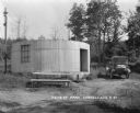
| Date: | 1927 |
|---|---|
| Description: | A cylinder-shaped cement building with an open door in a rural area. In front of the building is a picnic table, and on the right an automobile is parked n... |
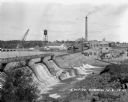
| Date: | 1927 |
|---|---|
| Description: | Elevated view over dam of the site of the Cornell Wood Products Company. On the opposite shoreline is a pulpwood stacker, tall smokestack, water tower, and... |

| Date: | |
|---|---|
| Description: | Memohead of Seymour's Bank in Chippewa Falls, Wisconsin, with a three-quarter view of the bank building, including people coming and going on the sidewalk ... |
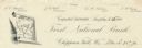
| Date: | |
|---|---|
| Description: | Numbered letterhead of the First National Bank, with a map of Wisconsin and a starred location marker for Chippewa Falls, a medallion, and a flowering stal... |

| Date: | 1920 |
|---|---|
| Description: | Three men and a woman pose with a pole of a stringer of fish. One of the men holds his pet dog. Behind them on the left is a bathtub, hand-pump for water, ... |

| Date: | 1900 |
|---|---|
| Description: | This early 20th century map of Chippewa County, Wisconsin, shows the township and range grid, towns, sections, cities and villages, roads, railroads, schoo... |

| Date: | 1918 |
|---|---|
| Description: | This 1918 map of Chippewa County, Wisconsin, shows the township and range grid, towns, sections, cities and villages, rural residences, churches, schools, ... |

| Date: | 1930 |
|---|---|
| Description: | This road map of Chippewa County, Wisconsin, dates to around 1930. It shows the township and range grid, towns, sections, cities and villages, railroads, l... |

| Date: | 1873 |
|---|---|
| Description: | This 1873 map of Chippewa County, Wisconsin, which at the time also encompassed all or part of Price, Rusk, Sawyer, and Taylor counties, shows the township... |
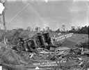
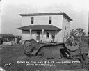
| Date: | 08 07 1924 |
|---|---|
| Description: | An overturned car sits among broken pieces of wood, including a broken chair, in a field. An arrow and the words: "Richard Sikora Killed Here" points to th... |
| Date: | 08 07 1924 |
|---|---|
| Description: | The aftermath of a killer tornado, including an arrow and caption that reads: "William Berg Killed Here." In the background near the farmhouse are a group ... |
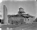
| Date: | 08 07 1924 |
|---|---|
| Description: | View across railroad tracks of the canning factory in the aftermath of a tornado. The top of the brick structure and the smokestack has been blown off. Pil... |
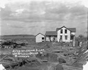
| Date: | 08 07 1924 |
|---|---|
| Description: | View across yard of a storm-damaged farmhouse. In the foreground is an overturned automobile. The windows of the house have been blown out and the roof has... |
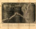
| Date: | 1881 |
|---|---|
| Description: | This map of Chippewa Falls is a proposal of river improvements using booming and rafting facilities and shows the city of Chippewa Falls, the Chippewa Rive... |

| Date: | 1951 |
|---|---|
| Description: | This map of Chippewa Falls shows the city of Chippewa River, city limits, roads, highways, fair grounds, and parks. |
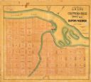
| Date: | 1800 |
|---|---|
| Description: | This map of Chippewa Falls is a lithograph and shows plats, labeled streets, landings, some businesses, and the Chippewa River. The map was drawn "from act... |

| Date: | 1938 |
|---|---|
| Description: | This map shows plat of town, land ownership by name, city limits, section boundaries, wards, local roads, railroads, parks, fairgrounds, cemeteries, locati... |

| Date: | 1975 |
|---|---|
| Description: | This standard U.S.G.S. topographic map was annotated by civil engineer and railroad historian James P. Kaysen to show the location of existing and defunct ... |

| Date: | 1916 |
|---|---|
| Description: | Hand-colored postcard view from across street towards the Chippewa Falls High School on North Bridge Street. Caption reads: "High School, Chippewa Falls, W... |

| Date: | 1910 |
|---|---|
| Description: | Hand-colored postcard view looking up a unpaved road and sidewalk at McDonell Memorial High School and Notre Dame church with the nuns' convent in the back... |
If you didn't find the material you searched for, our Library Reference Staff can help.
Call our reference desk at 608-264-6535 or email us at: