Filter: Categories of Wisconsin Historical Images
Filter: County of Chippewa
Filter: Subject of cities and towns
Filter: Categories of Wisconsin Historical Images
Filter: County of Chippewa
Filter: Subject of cities and towns

| Date: | 1940 |
|---|---|
| Description: | Looking north on Bridge Street from Spring Street intersection. In foreground, left, is a bank. In foreground, right, is a restaurant with a neon sign that... |

| Date: | 1912 |
|---|---|
| Description: | This blueprint manuscript map shows landownership, mills, railroad, churches, public buildings, the old cemetery, and the Chippewa River and Reservoir. The... |
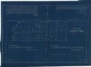
| Date: | 11 1925 |
|---|---|
| Description: | This blueprint manuscript map shows an addition. The map was surveyed and platted for B.G. Proctor, president, and George Peterson, secretary, of the Corne... |

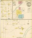
| Date: | 1900 |
|---|---|
| Description: | This photocopy map shows block and lot numbers with landowner names, additions, selected buildings, and the Yellow River. |

| Date: | |
|---|---|
| Description: | A blueprint map of a portion of Chippewa County. |

| Date: | 1908 |
|---|---|
| Description: | View of a hotel in Holcombe with steps up to a porch with columns at the entrance, and a balcony above. A sign on the side of the building reads: "The Jour... |

| Date: | 1908 |
|---|---|
| Description: | Elevated view of Holcombe, with the dam on the Chippewa River in the foreground. Caption reads: "Birds-Eye View, Holcombe, Wis." |

| Date: | |
|---|---|
| Description: | View across unpaved street in Holcombe. There is a long row of parked automobiles in front of a barbershop at the end of the block. Laundry is drying on li... |
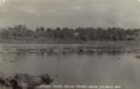
| Date: | |
|---|---|
| Description: | View from shoreline across the Chippewa River. There is a church on the opposite shoreline behind trees. Caption reads: "Chippewa River below power house, ... |
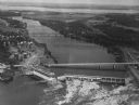
| Date: | 1950 |
|---|---|
| Description: | Aerial view of a hydroelectric power plant owned by Northern States Power Company located on the Chippewa River. A highway bridge and a railroad bridge spa... |
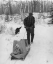
| Date: | 1976 |
|---|---|
| Description: | Elderly man pulling a sled loaded with packages and bags. He is wearing a plaid coat. His dog is sniffing the snow. Trees cover a snow covered berm in the ... |
If you didn't find the material you searched for, our Library Reference Staff can help.
Call our reference desk at 608-264-6535 or email us at: