 Filter: Categories of Wisconsin Historical Images
Filter: County of Chippewa
Filter: Subject of cities and towns
Filter: Year of 1800-1899
Filter: Subject of land
Filter: Categories of Wisconsin Historical Images
Filter: County of Chippewa
Filter: Subject of cities and towns
Filter: Year of 1800-1899
Filter: Subject of land
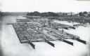
| Date: | 1870 |
|---|---|
| Description: | Elevated view of lumber raft and workers on the Chippewa River. In the background on the right are dwellings. |
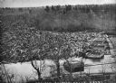
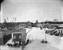
| Date: | 1869 |
|---|---|
| Description: | Elevated view from steep shoreline of a log jam of about 150 million feet of logs, stopped at the piers of Pound, Halbert, and Co., which stood in about 40... |

| Date: | 1850 |
|---|---|
| Description: | Painting depicting Chippewa Falls and the first sawmill on the Chippewa River, built by Jean Brunet. The residence of H.S. Allen, one of the owners of the... |

| Date: | 1886 |
|---|---|
| Description: | Bird's-eye map of Chippewa Falls, county seat of Chippewa Falls. |

| Date: | 1874 |
|---|---|
| Description: | Bird's-eye map of Chippewa Falls. |
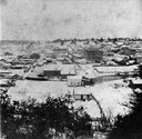
| Date: | 1870 |
|---|---|
| Description: | Elevated view of Chippewa Falls during the winter. |
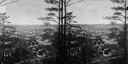
| Date: | 1890 |
|---|---|
| Description: | Elevated view of Chippewa Falls seen through trees. |
| Date: | 1898 |
|---|---|
| Description: | Elevated winter view of the Leinenkugel Brewery seen "from top of Mill." Originally called "Spring Brewery," Jacob Leinenkugel opened his brewery in 1867 i... |

| Date: | 1873 |
|---|---|
| Description: | This 1873 map of Chippewa County, Wisconsin, which at the time also encompassed all or part of Price, Rusk, Sawyer, and Taylor counties, shows the township... |
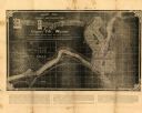
| Date: | 1881 |
|---|---|
| Description: | This map of Chippewa Falls is a proposal of river improvements using booming and rafting facilities and shows the city of Chippewa Falls, the Chippewa Rive... |
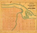
| Date: | 1800 |
|---|---|
| Description: | This map of Chippewa Falls is a lithograph and shows plats, labeled streets, landings, some businesses, and the Chippewa River. The map was drawn "from act... |
If you didn't find the material you searched for, our Library Reference Staff can help.
Call our reference desk at 608-264-6535 or email us at:
