Filter: Categories of Wisconsin Historical Images
Filter: County of Chippewa
Filter: Subject of cities and towns
Filter: Year of 1800-1899
Filter: Type of Map or Atlas
Filter: Categories of Wisconsin Historical Images
Filter: County of Chippewa
Filter: Subject of cities and towns
Filter: Year of 1800-1899
Filter: Type of Map or Atlas

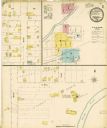
| Date: | 1886 |
|---|---|
| Description: | Bird's-eye map of Chippewa Falls, county seat of Chippewa Falls. |

| Date: | 1874 |
|---|---|
| Description: | Bird's-eye map of Chippewa Falls. |

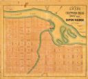
| Date: | 1867 |
|---|---|
| Description: | Drawn map showing planned development of Cornell, including a couple of schools, Oakwood cemetery, the public square, and several bridges and dams. |

| Date: | 1873 |
|---|---|
| Description: | This 1873 map of Chippewa County, Wisconsin, which at the time also encompassed all or part of Price, Rusk, Sawyer, and Taylor counties, shows the township... |
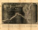
| Date: | 1881 |
|---|---|
| Description: | This map of Chippewa Falls is a proposal of river improvements using booming and rafting facilities and shows the city of Chippewa Falls, the Chippewa Rive... |
| Date: | 1800 |
|---|---|
| Description: | This map of Chippewa Falls is a lithograph and shows plats, labeled streets, landings, some businesses, and the Chippewa River. The map was drawn "from act... |
If you didn't find the material you searched for, our Library Reference Staff can help.
Call our reference desk at 608-264-6535 or email us at: