Filter: Categories of Wisconsin Historical Images
Filter: County of Chippewa
Filter: Subject of cities and towns
Filter: Subject of transportation
Filter: Categories of Wisconsin Historical Images
Filter: County of Chippewa
Filter: Subject of cities and towns
Filter: Subject of transportation

| Date: | 1910 |
|---|---|
| Description: | Hand-colored postcard view looking up a unpaved road and sidewalk at McDonell Memorial High School and Notre Dame church with the nuns' convent in the back... |
| Date: | 1920 |
|---|---|
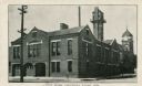
| Description: | View from street of Chippewa Falls city hall. On the left are garage doors for fire engine storage, and a watch tower is at upper right. Another building ... |

| Date: | 1920 |
|---|---|
| Description: | Hand-colored postcard view of St. Joseph's Hospital. The view is facing south-west and reveals a large fenced side lawn with foot paths, plants and six peo... |

| Date: | 1920 |
|---|---|
| Description: | Color postcard view across street towards the St. Joseph's Hospital. An automobile is parked at the curb in front. Caption reads: "St. Joseph's Hospital, C... |

| Date: | 1936 |
|---|---|
| Description: | View from street towards the St. Joseph's Hospital. In the center is a two level open porch, with two people on the second level. A 1930s automobile is par... |

| Date: | 1910 |
|---|---|
| Description: | View across street towards the library, constructed of cut stone, one-story with raised basement. Caption reads: "Carnegie Library, Chippewa Falls, Wis." |

| Date: | 1940 |
|---|---|
| Description: | Exterior view of Hotel Northern, five stories tall. Caption reads: "Hotel Northern, Chippewa Falls, Wisconsin, Fire Proof." |

| Date: | 1920 |
|---|---|
| Description: | Photographic postcard view from street of St. Joseph's Hospital. Caption reads: "St. Joseph's Hospital, Chippewa Falls, Wis." |
| Date: | 1910 |
|---|---|
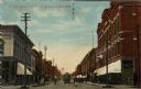
| Description: | Colorized view of Bridge Street, looking north from Spring Street intersection, in the central business district. The view includes stores, some with canva... |

| Date: | 1940 |
|---|---|
| Description: | Looking north on Bridge Street from Spring Street intersection. In foreground, left, is a bank. In foreground, right, is a restaurant with a neon sign that... |

| Date: | 1912 |
|---|---|
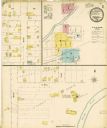
| Description: | This blueprint manuscript map shows landownership, mills, railroad, churches, public buildings, the old cemetery, and the Chippewa River and Reservoir. The... |

| Date: | 1900 |
|---|---|
| Description: | This photocopy map shows block and lot numbers with landowner names, additions, selected buildings, and the Yellow River. |

| Date: | 1908 |
|---|---|
| Description: | Elevated view of Holcombe, with the dam on the Chippewa River in the foreground. Caption reads: "Birds-Eye View, Holcombe, Wis." |

| Date: | |
|---|---|
| Description: | View across unpaved street in Holcombe. There is a long row of parked automobiles in front of a barbershop at the end of the block. Laundry is drying on li... |
If you didn't find the material you searched for, our Library Reference Staff can help.
Call our reference desk at 608-264-6535 or email us at: