 Filter: Categories of Wisconsin Historical Images
Filter: County of Chippewa
Filter: Subject of cities and towns
Filter: Community of Chippewa Falls
Filter: Categories of Wisconsin Historical Images
Filter: County of Chippewa
Filter: Subject of cities and towns
Filter: Community of Chippewa Falls
| Date: | |
|---|---|
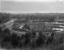
| Description: | Elevated view of park-like, lightly-wooded area with Duncan Creek running through it. A dirt road runs over a bridge to the left. The skyline of Chippewa F... |

| Date: | |
|---|---|
| Description: | Elevated view looking North down middle of Bridge Street. Both sides of the street are lined with commercial buildings. There are several horse-drawn vehic... |
| Date: | 1903 |
|---|---|
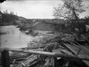
| Description: | View of the wreckage of wooden structures lying on the shoreline of a river after a flood. A dam across the river has been partially washed away. A man is ... |
| Date: | 1903 |
|---|---|
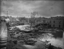
| Description: | View from railroads tracks of the wreckage of wooden buildings left behind after a flood. Intact buildings are visible in a skyline in the distance, and pe... |
| Date: | 1900 |
|---|---|
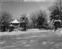
| Description: | The inter-urban street car terminal station shelter at Irvine Park. A heavy snowfall covers the landscape. A stone wall gateway with lampposts and decorati... |

| Date: | 1926 |
|---|---|
| Description: | A busy street scene. Cars are parked at the curbs on either side of the street. Two women walk on the sidewalk. An American flag flies from the top of a bu... |
| Date: | 1926 |
|---|---|
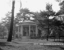
| Description: | A gazebo dedicated to solders and sailors in Irvine Park. A flagpole and benches are in front of the gazebo. |

| Date: | 1926 |
|---|---|
| Description: | Exterior of the Hotel Northern. The hotel has a Western Union and drugstore on the street level. An American flag flies from the top of the building. |

| Date: | 1926 |
|---|---|
| Description: | Exterior of the Edward Rutledge Charity. There is a sign for the tourist camp and Irvine Park on the lamppost. |

| Date: | |
|---|---|
| Description: | Memohead of Seymour's Bank in Chippewa Falls, Wisconsin, with a three-quarter view of the bank building, including people coming and going on the sidewalk ... |
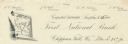
| Date: | |
|---|---|
| Description: | Numbered letterhead of the First National Bank, with a map of Wisconsin and a starred location marker for Chippewa Falls, a medallion, and a flowering stal... |
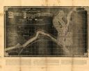
| Date: | 1881 |
|---|---|
| Description: | This map of Chippewa Falls is a proposal of river improvements using booming and rafting facilities and shows the city of Chippewa Falls, the Chippewa Rive... |

| Date: | 1951 |
|---|---|
| Description: | This map of Chippewa Falls shows the city of Chippewa River, city limits, roads, highways, fair grounds, and parks. |
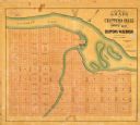
| Date: | 1800 |
|---|---|
| Description: | This map of Chippewa Falls is a lithograph and shows plats, labeled streets, landings, some businesses, and the Chippewa River. The map was drawn "from act... |

| Date: | 1938 |
|---|---|
| Description: | This map shows plat of town, land ownership by name, city limits, section boundaries, wards, local roads, railroads, parks, fairgrounds, cemeteries, locati... |

| Date: | 1916 |
|---|---|
| Description: | Hand-colored postcard view from across street towards the Chippewa Falls High School on North Bridge Street. Caption reads: "High School, Chippewa Falls, W... |

| Date: | 1910 |
|---|---|
| Description: | Hand-colored postcard view looking up a unpaved road and sidewalk at McDonell Memorial High School and Notre Dame church with the nuns' convent in the back... |
| Date: | 1920 |
|---|---|
| Description: | View from street of Chippewa Falls city hall. On the left are garage doors for fire engine storage, and a watch tower is at upper right. Another building ... |
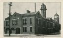
| Date: | 1950 |
|---|---|
| Description: | Color postcard of new County Court House, a two-story white granite building with elm trees in front. |

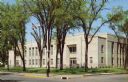
| Date: | 1915 |
|---|---|
| Description: | Color postcard of Chippewa County Court House at Chippewa Falls. Caption reads: "Chippewa County Court House, Chippewa Falls, Wis." |
If you didn't find the material you searched for, our Library Reference Staff can help.
Call our reference desk at 608-264-6535 or email us at: