Filter: Categories of Wisconsin Historical Images
Filter: County of Chippewa
Filter: Community of New Auburn
Filter: Categories of Wisconsin Historical Images
Filter: County of Chippewa
Filter: Community of New Auburn

| Date: | 1910 |
|---|---|
| Description: | Cover of brochure for Old Timer's Resort (formerly Burke's Resort). |

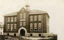
| Date: | 1905 |
|---|---|
| Description: | Clockwise from upper left images include: Cutters Point, Long Lake, Wis.; M.E. Church, New Auburn, Wis.; Farmers Store, New Auburn, Wis.; Public School, Ne... |
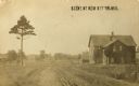
| Date: | 1905 |
|---|---|
| Description: | View down dirt road with a tree on the left, and a building (house?) on the right. More buildings are further down the road. Caption reads: "Scene at New A... |
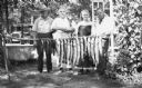
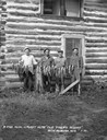
| Date: | 1920 |
|---|---|
| Description: | Three men and a woman pose with a pole of a stringer of fish. One of the men holds his pet dog. Behind them on the left is a bathtub, hand-pump for water, ... |
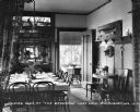
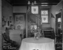
| Date: | 1926 |
|---|---|
| Description: | Dining room at the Basswood in Long Lake. Fish are mounted on the wall on the right, and along the back wall is a china cabinet with stained glass above. T... |
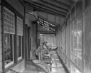
| Date: | 08 1926 |
|---|---|
| Description: | A man works at the front desk at the lobby of the Basswood resort in Long Lake. The room features a table and chairs, stained glass windows, a calendar, an... |
| Date: | 1926 |
|---|---|
| Description: | Vacationers sitting on wicker chairs on the enclosed porch at the Basswood in Long Lake. |
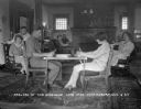
| Date: | 1926 |
|---|---|
| Description: | Vacationers in the parlor of the Basswood in Long Lake. A banner on the piano in the background says: "Northern Wis. State Fair." |
| Date: | 1930 |
|---|---|
| Description: | Group portrait of four men standing behind a row of fish on a stringer. Two large muskies are in the center. The men are standing in front of a two-story l... |

| Date: | 1975 |
|---|---|
| Description: | This standard U.S.G.S. topographic map was annotated by civil engineer and railroad historian James P. Kaysen to show the location of existing and defunct ... |
If you didn't find the material you searched for, our Library Reference Staff can help.
Call our reference desk at 608-264-6535 or email us at: