 Filter: Categories of Wisconsin Historical Images
Filter: County of Buffalo
Filter: Year of 1800-1899
Filter: Categories of Wisconsin Historical Images
Filter: County of Buffalo
Filter: Year of 1800-1899
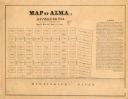
| Date: | 1800 |
|---|---|
| Description: | Map shows plat of the town Alma and the Mississippi River. Streets running horizontally begin at the top with "SIXTH STREET" and end with "MAIN STREET." St... |

| Date: | 1894 |
|---|---|
| Description: | Elevated view looking down at wagons and crowd gathering for McCormick Day parade. "McCormick Day" was a promotional device sponsored by the McCormick Harv... |
| Date: | 1895 |
|---|---|
| Description: | Large group of farm adults and children, probably of German extraction, of one or more families, gathered under fruit trees at the edge of a cornfield, pre... |

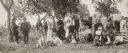
| Date: | 1888 |
|---|---|
| Description: | Outdoor group portrait of magistrates sitting around a table in front of the fire house. Identified (left to right): Edward Funke, William Schuster, David ... |

| Date: | 1895 |
|---|---|
| Description: | View across water towards a house on the banks of the Mississippi River at the base of rocky bluffs. Probably located between Alma and Nelson, along Beef S... |

| Date: | 1856 |
|---|---|
| Description: | This map shows the city as planned by the General Colonization Society, including streets, land parcels, two subdivisions of out-lots with graveyard, schoo... |
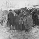
| Date: | 1888 |
|---|---|
| Description: | Outdoor group portrait of a man, woman, and three children. The man is holding a rifle. Caption reads: "Chief Winneshiek. Picture taken in camp near Founta... |
If you didn't find the material you searched for, our Library Reference Staff can help.
Call our reference desk at 608-264-6535 or email us at: