Filter: Categories of Wisconsin Historical Images
Filter: County of Brown
Filter: Year of 1800-1899
Filter: Year of 1870-1879
Filter: Categories of Wisconsin Historical Images
Filter: County of Brown
Filter: Year of 1800-1899
Filter: Year of 1870-1879

| Date: | 1873 |
|---|---|
| Description: | At the De Pere depot, the first train operated by the Milwaukee & Northern Railway. This train made its first run to Green Bay on June 25, 1873, and this p... |

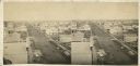
| Date: | 1875 |
|---|---|
| Description: | Elevated view of a shopping district street near a river, with several businesses lining the street, and two carriages. A building across the street has le... |
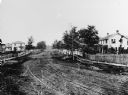
| Date: | 1870 |
|---|---|
| Description: | View of dirt road with houses along both sides, and wooden walkways and picket fences along the road. |

| Date: | 1870 |
|---|---|
| Description: | View of the California house next to a store with a sign that reads: "M. Silber & Bro.," and a "Boot & Shoe Store." A bakery is on the left, and a group of... |

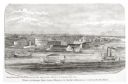
| Date: | 1876 |
|---|---|
| Description: | Elevated view showing Elmore and Kelly's Elevator with a boat, train, and the buildings at Fort Howard. Fort Howard was incorporated into Green Bay. Captio... |
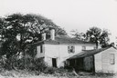
| Date: | 1870 |
|---|---|
| Description: | Exterior of the Cadle Home, an Episcopal Home for aged people. The Cadle Home was named for Reverend Cadle who went to Green Bay in 1829 as the first local... |
| Date: | 1870 |
|---|---|
| Description: | Elevated view of Main Street and Green Bay House seen from the top of the Beaumont House. |

| Date: | 1870 |
|---|---|
| Description: | Five piece panoramic view of the Green Bay waterfront area. |
| Date: | 1876 |
|---|---|
| Description: | View looking southeast over river from Elmore and Kelly's Elevator. |
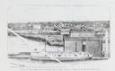
| Date: | 1876 |
|---|---|
| Description: | Drawing of a ship being loaded by Elmore & Kelly's Elevator on Fort Howard River looking north. A town and a train are in the background. |
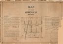
| Date: | 1873 |
|---|---|
| Description: | A plat of the village of Greenleaf, Brown County, Wisconsin, showing the areas from Taintor Street to Day Street and Follett Street to Deuster Street. Inc... |

| Date: | 1870 |
|---|---|
| Description: | This 1870 map of Brown County, Wisconsin, shows the township and range grid, towns, sections, cities, villages and post offices, land ownership, roads, rai... |

| Date: | 1875 |
|---|---|
| Description: | Elevated view over De Pere. In the foreground is the De Pere News Office and Post Office building. Behind it people are walking on the bridge over the Fox ... |

| Date: | 1870 |
|---|---|
| Description: | Section of overall panorama, showing railroad station. |

| Date: | 1875 |
|---|---|
| Description: | View over town looking east from the railroad station. |

| Date: | 1874 |
|---|---|
| Description: | This map shows streets, buildings, railroads, the Fox River, the East River, and part of Green Bay. |

| Date: | 1875 |
|---|---|
| Description: | Handwritten note on back identifies this elevated view as the west side of Broadway from National Bank, looking south. The Fox River is in the background o... |
If you didn't find the material you searched for, our Library Reference Staff can help.
Call our reference desk at 608-264-6535 or email us at: