 Filter: Categories of Wisconsin Historical Images
Filter: County of Brown
Filter: Subject of human settlements
Filter: Categories of Wisconsin Historical Images
Filter: County of Brown
Filter: Subject of human settlements

| Date: | 1957 |
|---|---|
| Description: | Large Letter style postcard for Green Bay depicting various scenes in the letters that spell the name of the city. Caption reads: "Greetings from Green Bay... |
| Date: | 06 08 1959 |
|---|---|
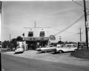
| Description: | Exterior view of Noel's Bait and Sport Shop with cars parked in the lot in front of the building. Fishing nets can be seen on display in the window. The bu... |
| Date: | 09 25 1957 |
|---|---|
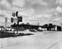
| Description: | Exterior view from road of Sneezer's Snack Shop with two cars in the parking lot. The neon sign features a chef holding a hamburger on a plate. |

| Date: | 10 13 1919 |
|---|---|
| Description: | Exterior view of an International Harvester Green Bay branch office building. What appears to be an Auto Wagon and other automobiles are in the display win... |
| Date: | |
|---|---|
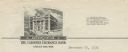
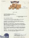
| Description: | Letterhead of the Farmers Exchange Bank of Green Bay, Wisconsin, with a three-quarter view of the bank building and people walking on the sidewalk. There a... |

| Date: | |
|---|---|
| Description: | Memohead of the Henry Rahr Sons' Company of Green Bay, Wisconsin, brewers and maltsters, with an elevated view of the main office at 1317-1323 Main St. on ... |

| Date: | 1835 |
|---|---|
| Description: | Ink on tracing paper map of Green Bay, Wisconsin and nearby areas, Lake Winnebago, Fox and Wolf Rivers, and the junctions of the Mississippi and Wisconsin ... |
| Date: | 1856 |
|---|---|
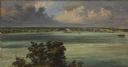
| Description: | ". . . At De Pere they stopped on the west shore for a broad sketch of the dwellings clustered on both sides of the river. The distant dam, the mills, ware... |
| Date: | |
|---|---|
| Description: | Letterhead of Steve's Cheese of Denmark, Wisconsin, with a man standing amidst seven large (300-12,000 lbs.) wheels of cheese on individual pallets, and a ... |

| Date: | 1914 |
|---|---|
| Description: | This map is a photostat copy from the original 1829 map in the War Department. The map shows location of Fort Howard, lots, land claims of Jacques Porlier ... |
| Date: | 1930 |
|---|---|
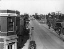
| Description: | Elevated view of High Street (Highway 96) and the bridge over the Fox River at Wrightstown. Farmers & Traders Bank is at left, a sign for Meuleman's Elect... |
| Date: | 1873 |
|---|---|
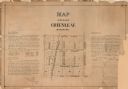
| Description: | A plat of the village of Greenleaf, Brown County, Wisconsin, showing the areas from Taintor Street to Day Street and Follett Street to Deuster Street. Inc... |

| Date: | 1908 |
|---|---|
| Description: | This 1908 map shows the township and range grid, sections, towns, villages, railroads, bridges, lakes, streams, rapids, and state-owned lands in Oneida Cou... |

| Date: | 1959 |
|---|---|
| Description: | This map identifies public forest land and industrial forest land as of 1959 in Oneida County, Wisconsin, using a 1930 base map showing the township and ra... |

| Date: | |
|---|---|
| Description: | This 19th century manuscript map shows lots and acreages in northern Green Bay, Wisconsin, east of the Fox River. "Preble Township, Brown County, Wis." is ... |

| Date: | 1836 |
|---|---|
| Description: | This manuscript shows the 1835 survey of the road corresponding approximately to a portion of County Trunk A in the Town of Scott, Brown County, Wisconsin.... |

| Date: | 1870 |
|---|---|
| Description: | This 1870 map of Brown County, Wisconsin, shows the township and range grid, towns, sections, cities, villages and post offices, land ownership, roads, rai... |

| Date: | 1896 |
|---|---|
| Description: | This map of Brown County, Wisconsin, from the late 19th century shows land claims along the Fox River, the township and range grid, towns, sections, cities... |
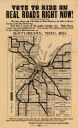
| Date: | 1919 |
|---|---|
| Description: | This flier, likely printed in 1919, promotes the vote for a bond issue to fund "hard roads" in Brown County, Wisconsin. The map shows the 135 miles of conc... |

| Date: | 1903 |
|---|---|
| Description: | Map of Brown County, Wisconsin, shows the township and range grid, towns, sections, cities, villages and post offices, land owners and acreages, railroads,... |
If you didn't find the material you searched for, our Library Reference Staff can help.
Call our reference desk at 608-264-6535 or email us at: