 Filter: Categories of Wisconsin Historical Images
Filter: County of Brown
Filter: Subject of human settlements
Filter: Subject of technology
Filter: Categories of Wisconsin Historical Images
Filter: County of Brown
Filter: Subject of human settlements
Filter: Subject of technology

| Date: | 1867 |
|---|---|
| Description: | Bird's-eye map of Green Bay and Fort Howard, Brown Co., depicts street names and street layouts, houses, trees, and the East River. A reference key at the ... |

| Date: | 1950 |
|---|---|
| Description: | Caption reads: "Looking West on Main Ave." View down center of commercial area, with automobiles moving down the street, and parked along the curbs. A U.S.... |
| Date: | 1860 |
|---|---|
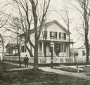
| Description: | Exterior of the Chapman residence, at the corner of Walnut and Adams Streets. A man is standing on the sidewalk in front. |

| Date: | 1920 |
|---|---|
| Description: | Exterior view across street towards the Northern Building, with cars parked along the curb near lampposts. Caption reads: "New Northern Building, Green Bay... |

| Date: | 1920 |
|---|---|
| Description: | Exterior view across street toward the Young Men's Christian Association. Caption reads: "Y.M.C.A. - Green Bay, Wis." |
| Date: | 1975 |
|---|---|
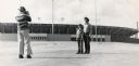
| Description: | The O'Brien family posing in the Lambeau Field parking lot, reenacting a photograph frequently taken by Packers fans. |

| Date: | |
|---|---|
| Description: | This map surveyed under the direction of Capt. Thomas J. Cram is one in a series of seven. The map shows part of the Fox River and the beginning of the tow... |
| Date: | 01 1963 |
|---|---|
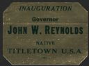
| Description: | A shiny sticker for the inauguration of Wisconsin Governor John W. Reynolds (4/4/1921 – 1/6/2002), Jr. that highlights his status as a native of "Titletown... |
| Date: | 06 08 1959 |
|---|---|
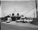
| Description: | Exterior view of Noel's Bait and Sport Shop with cars parked in the lot in front of the building. Fishing nets can be seen on display in the window. The bu... |
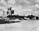
| Date: | 09 25 1957 |
|---|---|
| Description: | Exterior view from road of Sneezer's Snack Shop with two cars in the parking lot. The neon sign features a chef holding a hamburger on a plate. |

| Date: | 1836 |
|---|---|
| Description: | This manuscript shows the 1835 survey of the road corresponding approximately to a portion of County Trunk A in the Town of Scott, Brown County, Wisconsin.... |

| Date: | 09 20 1836 |
|---|---|
| Description: | This map is ink and watercolor on paper and is an unnamed plat. Green Bay is labeled and the plat is labeled "Section 22." One road is labeled "Road to Nav... |
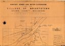
| Date: | 1961 |
|---|---|
| Description: | This map shows a sewage treatment plant site and includes an index of "Title and Index," "Watermain Details," "Sanitary Sewer Details," and "Plan B Profile... |

| Date: | 1929 |
|---|---|
| Description: | View from street towards the Denmark State Bank, which is heavily covered with ivy. There is a flagpole at the corner flying the American flag. Caption rea... |

| Date: | 04 11 1940 |
|---|---|
| Description: | This blue line print map shows survey monument markers by type and industrial buildings and covers part of the lower Fox River and East River. The map incl... |
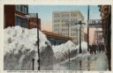
| Date: | 03 09 1918 |
|---|---|
| Description: | View of a city sidewalk after a snow storm, with tall piles of snow along the curb. Men are walking along the sidewalk. Caption reads: "Green Bay's Worst S... |

| Date: | |
|---|---|
| Description: | Colorized postcard view of Washington Street at an intersection. Commercial buildings are on both sides of the street, with automobiles parked along the cu... |

| Date: | 1950 |
|---|---|
| Description: | Colorized postcard view down street towards a shopping district, which is lined with shops: Walgreen's, Prange's, and Kinney Shoes. Automobiles are parked ... |

| Date: | 1875 |
|---|---|
| Description: | Elevated view of several buildings, with bridge and railroad tracks, and the Fox River. In the foreground on the right is the Commercial House, with three ... |
If you didn't find the material you searched for, our Library Reference Staff can help.
Call our reference desk at 608-264-6535 or email us at: