Filter: Categories of Wisconsin Historical Images
Filter: County of Brown
Filter: Subject of human settlements
Filter: Subject of service industries
Filter: Categories of Wisconsin Historical Images
Filter: County of Brown
Filter: Subject of human settlements
Filter: Subject of service industries
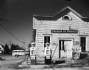
| Date: | 10 13 1963 |
|---|---|
| Description: | Gasoline station, with Standard Oil Products and Champion signs, in old false front building. |

| Date: | 1867 |
|---|---|
| Description: | Bird's-eye map of Green Bay and Fort Howard, Brown Co., depicts street names and street layouts, houses, trees, and the East River. A reference key at the ... |
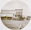
| Date: | |
|---|---|
| Description: | Man on horse-drawn wagon loaded with sacks in front of Lee & Diebels Company. |
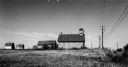
| Date: | 1920 |
|---|---|
| Description: | Charcoal kiln in ruins in a field beyond a fence, with electric power lines in the background. |

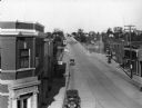
| Date: | 1950 |
|---|---|
| Description: | Caption reads: "Looking West on Main Ave." View down center of commercial area, with automobiles moving down the street, and parked along the curbs. A U.S.... |
| Date: | 1913 |
|---|---|
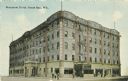
| Description: | View from intersection toward the hotel. Caption reads: "Beaumont Hotel, Green Bay, Wis." |

| Date: | 1910 |
|---|---|
| Description: | View from road toward Mineral Springs. There is a board sidewalk in the foreground. Caption reads: "Mineral Sprints, Green Bay, Wis." |
| Date: | 1910 |
|---|---|
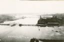
| Description: | Elevated view from the tower of the Northern Hydro-Electric Power Company on the Fox River. Caption reads: "Bird's Eye View from Tower of Northern Hydro-El... |

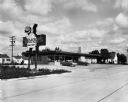
| Date: | 1965 |
|---|---|
| Description: | The Valley Motel and Colonial Restaurant at the intersection of Highways 41 and 29. This motel boasts that it has a large lighted swimming pool as well as ... |
| Date: | 1930 |
|---|---|
| Description: | Gas station. The Tudor-revival style of this station represents gas station owners' trend to adopt domestic architectural styles as they moved into residen... |

| Date: | 11 15 1937 |
|---|---|
| Description: | An International truck used by the Leicht Transfer & Storage Co. parked in a driveway beside a residence and a garage. A man is sitting in the cab. The let... |
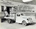
| Date: | 12 22 1937 |
|---|---|
| Description: | A man on a loading dock near the open door of a building loads metal parts onto the back of an International truck used by the Wesley Heat Treating Company... |
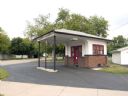
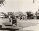
| Date: | 2008 |
|---|---|
| Description: | Located at 159 Pulaski Street, this house-style station featuring a hip-roof canopy, was built in 1925 by Vincent Zielinski. |

| Date: | 08 18 1963 |
|---|---|
| Description: | Exterior view of an abandoned "Bonus" gasoline station. This station was formerly a Wadham's Oil and Grease Company station. The Wadham's chain, headquarte... |

| Date: | 1957 |
|---|---|
| Description: | Large Letter style postcard for Green Bay depicting various scenes in the letters that spell the name of the city. Caption reads: "Greetings from Green Bay... |
| Date: | 09 25 1957 |
|---|---|
| Description: | Exterior view from road of Sneezer's Snack Shop with two cars in the parking lot. The neon sign features a chef holding a hamburger on a plate. |
| Date: | 1930 |
|---|---|
| Description: | Elevated view of High Street (Highway 96) and the bridge over the Fox River at Wrightstown. Farmers & Traders Bank is at left, a sign for Meuleman's Elect... |

| Date: | 1870 |
|---|---|
| Description: | This 1870 map of Brown County, Wisconsin, shows the township and range grid, towns, sections, cities, villages and post offices, land ownership, roads, rai... |
If you didn't find the material you searched for, our Library Reference Staff can help.
Call our reference desk at 608-264-6535 or email us at: