Filter: Categories of Wisconsin Historical Images
Filter: County of Brown
Filter: Subject of human settlements
Filter: Subject of land
Filter: Categories of Wisconsin Historical Images
Filter: County of Brown
Filter: Subject of human settlements
Filter: Subject of land

| Date: | 1867 |
|---|---|
| Description: | Bird's-eye map of Green Bay and Fort Howard, Brown Co., depicts street names and street layouts, houses, trees, and the East River. A reference key at the ... |

| Date: | 1953 |
|---|---|
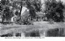
| Description: | Captain John Cotton residence. Also known as "Beaupre," this Greek Revival style house was built in 1842 for Cotton, a retired U.S. Army officer. |

| Date: | |
|---|---|
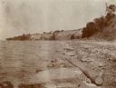
| Description: | Aerial view of a train crossing the East River in a rural community south of Green Bay. Some buildings are visible to the right and the background of the i... |
| Date: | 1927 |
|---|---|
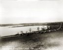
| Description: | View down hill towards the Fox River from the Eleazer Williams home. A group of people are automobiles are near a road near the shoreline. |
| Date: | 1898 |
|---|---|
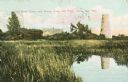
| Description: | Caption reads: "Old Stone Tower and House, Long Tail Point, Green Bay, Wis." Water and a marshy area are in the foreground. |

| Date: | 1905 |
|---|---|
| Description: | Long Tail Lighthouse and surrounding buildings. |
| Date: | 1910 |
|---|---|
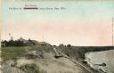
| Description: | Caption reads: "Old Light House at Long Tail Point, Green Bay, Wis." Built in 1859. A marshy area is in the foreground, and a long pier leads to the new li... |

| Date: | 1910 |
|---|---|
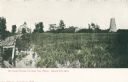
| Description: | View from road toward Mineral Springs. There is a board sidewalk in the foreground. Caption reads: "Mineral Sprints, Green Bay, Wis." |
| Date: | 1907 |
|---|---|
| Description: | View across water toward the Tank Cottage. Caption reads: "The Historic Tank Cottage — over 100 years old — Green Bay, Wis." |
| Date: | 1963 |
|---|---|
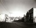
| Description: | View down middle of street of the main business district. |

| Date: | 1821 |
|---|---|
| Description: | Plan of the settlement of Green Bay. |
| Date: | 1910 |
|---|---|
| Description: | Walkway on the bluff leading down to a pavilion on the shoreline. Houses are in the background. Caption reads: "Pavilion at Bendersville, near Green Bay, W... |
| Date: | |
|---|---|
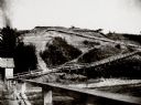
| Description: | A dock and wooden walk way leading to the top of an embankment. |

| Date: | |
|---|---|
| Description: | This map surveyed under the direction of Capt. Thomas J. Cram is one in a series of seven. The map shows part of the Fox River and the beginning of the tow... |

| Date: | 08 18 1963 |
|---|---|
| Description: | Two children stand on an outdoor stairway of wood-shingle house. Caption on back of print reads, "Back steps in 'Goosetown.' a section around Broadway and ... |

| Date: | 1835 |
|---|---|
| Description: | Ink on tracing paper map of Green Bay, Wisconsin and nearby areas, Lake Winnebago, Fox and Wolf Rivers, and the junctions of the Mississippi and Wisconsin ... |
| Date: | 1856 |
|---|---|
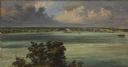
| Description: | ". . . At De Pere they stopped on the west shore for a broad sketch of the dwellings clustered on both sides of the river. The distant dam, the mills, ware... |
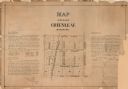
| Date: | 1873 |
|---|---|
| Description: | A plat of the village of Greenleaf, Brown County, Wisconsin, showing the areas from Taintor Street to Day Street and Follett Street to Deuster Street. Inc... |
If you didn't find the material you searched for, our Library Reference Staff can help.
Call our reference desk at 608-264-6535 or email us at: