 Filter: Categories of Wisconsin Historical Images
Filter: County of Brown
Filter: Subject of cities and towns
Filter: Categories of Wisconsin Historical Images
Filter: County of Brown
Filter: Subject of cities and towns
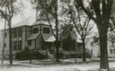
| Date: | 1910 |
|---|---|
| Description: | Caption reads: Presbyterian Church East De Pere." View from street of the church on a corner. |
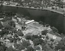
| Date: | 1948 |
|---|---|
| Description: | St. Norbert College campus on the Fox River. |
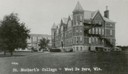
| Date: | 1910 |
|---|---|
| Description: | Caption reads: "St. Norbert's College - West De Pere." View across lawn towards buildings on the campus of St. Norbert's College. |
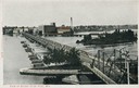
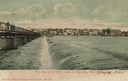
| Date: | 1906 |
|---|---|
| Description: | Elevated view of the bridge over the Fox River at De Pere. Caption reads: "View of Bridge at De Pere, Wis." |
| Date: | 1906 |
|---|---|
| Description: | The caption reads: "'The Dam at De Pere', south of Green Bay, Wis." View of the dam towards the far shoreline, with pedestrians walking on the bridge above... |
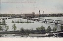
| Date: | 1906 |
|---|---|
| Description: | Elevated view. Caption reads: "Government Locks & Factory District, De Pere, Wis." |
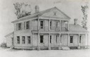
| Date: | 1962 |
|---|---|
| Description: | Drawing of the exterior of George White's home, 421 Cass Street. The house was built about 1835. |
| Date: | 1890 |
|---|---|
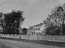
| Description: | Randall Wilcox's home, with trees and a sidewalk, built in 1836 or 1837. |
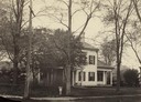
| Date: | 1867 |
|---|---|
| Description: | View across unpaved road towards Randall Wilcox's home, with a fence along the sidewalk. A group of people are standing on the front porch. |

| Date: | |
|---|---|
| Description: | View across yard towards the Wilcox-Lawton house with trees on the left. Built in 1838. |
| Date: | 1900 |
|---|---|
| Description: | A girl sits on a log next to Eleazer William's log cabin site. |

| Date: | 1953 |
|---|---|
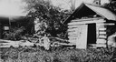
| Description: | Replica of Eleazer William's log cabin, with an archeological dig being conducted in front of the cabin. |

| Date: | 1876 |
|---|---|
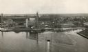
| Description: | Elevated view showing Elmore and Kelly's Elevator with a boat, train, and the buildings at Fort Howard. Fort Howard was incorporated into Green Bay. Captio... |
| Date: | 1920 |
|---|---|
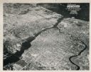
| Description: | Aerial view of the conluence of the Fox River and the East River. The Northern Paper Mills are in the foreground and the city is seen to the right. |

| Date: | 1955 |
|---|---|
| Description: | Aerial view of river and its surrounding landscape. |

| Date: | 1950 |
|---|---|
| Description: | Aerial view of fields near neighborhoods. |

| Date: | 1950 |
|---|---|
| Description: | Aerial view of the confluence of the Fox River and Green Bay. |
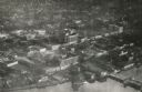
| Date: | 1948 |
|---|---|
| Description: | Aerial view of downtown area, with the Fox River and neighboring suburbs. |
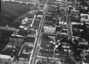
| Date: | 1920 |
|---|---|
| Description: | Aerial view of the commercial district on the east side of the Fox River. Left to right: Hurlbut Coal Company; suggested location for small terminal; Main... |
| Date: | 1924 |
|---|---|
| Description: | Aerial view of Green Bay's commercial district, bridges, and water. |
If you didn't find the material you searched for, our Library Reference Staff can help.
Call our reference desk at 608-264-6535 or email us at: