Filter: Categories of Wisconsin Historical Images
Filter: County of Brown
Filter: Subject of church buildings
Filter: Categories of Wisconsin Historical Images
Filter: County of Brown
Filter: Subject of church buildings

| Date: | 1867 |
|---|---|
| Description: | Bird's-eye map of Green Bay and Fort Howard, Brown Co., depicts street names and street layouts, houses, trees, and the East River. A reference key at the ... |

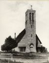
| Date: | 1890 |
|---|---|
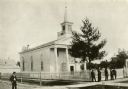
| Description: | Congregational Church at the corner of Broadway and Cass Street, with the entrance at the corner. The church has stained glass windows and a steeple. |
| Date: | 1910 |
|---|---|
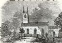
| Description: | First Congregational Church in De Pere. Buildings are in the background. |
| Date: | |
|---|---|
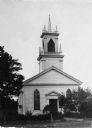
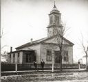
| Description: | View from unpaved street towards a church. Two men are standing ont he sidewalk in front of the picket fence in front of the church. The church was built i... |

| Date: | |
|---|---|
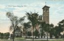
| Description: | View of the church. A dusting of snow is on the church lawn. The church has a tall spire, and stained-glass windows with gothic arches. First Presbyterian ... |
| Date: | 1832 |
|---|---|
| Description: | People work in the garden at the Protestant Episcopal Mission Buildings. |
| Date: | 1910 |
|---|---|
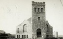
| Description: | Exterior view of St. John's Church. Caption reads: "St. John's Church, Green Bay, Wis." |
| Date: | |
|---|---|
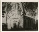
| Description: | St. Willebrord Roman Catholic Church, said to be the former town hall and Court House, built around 1850. |
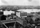
| Date: | 1889 |
|---|---|
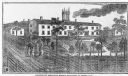
| Description: | Elevated view of Washington Street and the Fox River and buildings nearby. |
| Date: | 1900 |
|---|---|
| Description: | Hobart Episcopal Church on the Oneida Indian Reservation. |

| Date: | 1957 |
|---|---|
| Description: | Large Letter style postcard for Green Bay depicting various scenes in the letters that spell the name of the city. Caption reads: "Greetings from Green Bay... |

| Date: | 1896 |
|---|---|
| Description: | This map of Brown County, Wisconsin, from the late 19th century shows land claims along the Fox River, the township and range grid, towns, sections, cities... |

| Date: | 1903 |
|---|---|
| Description: | Map of Brown County, Wisconsin, shows the township and range grid, towns, sections, cities, villages and post offices, land owners and acreages, railroads,... |

| Date: | 1893 |
|---|---|
| Description: | Bird’s-eye view of Depere looking North. Includes illustrations and an index to points of interest. |

| Date: | 1963 |
|---|---|
| Description: | This blue line print shows as of March 1960 federal, state, county, and town roads, as well as railroads, schools, churches, town hall, parks, and Brown Co... |
If you didn't find the material you searched for, our Library Reference Staff can help.
Call our reference desk at 608-264-6535 or email us at: