 Filter: Categories of Wisconsin Historical Images
Filter: County of Bayfield
Filter: Year of 1900-1999
Filter: Year of 1910-1919
Filter: Categories of Wisconsin Historical Images
Filter: County of Bayfield
Filter: Year of 1900-1999
Filter: Year of 1910-1919
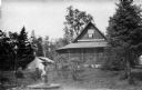
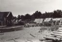
| Date: | 1915 |
|---|---|
| Description: | House, "Camp Stella," a.k.a. "Sevona Memorial Cottage," on Sand Island. The structure was orignally built by Sam S. Fifield, ex-Lieutenant Governor of Wisc... |
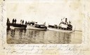
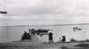
| Date: | 1912 |
|---|---|
| Description: | Boats and people at the Bayfield dock on Labor Day 1912. Boats include Thelma; Lusitania; which later became a U.S. Mail boat; Captain Angus'... |

| Date: | 1910 |
|---|---|
| Description: | Bird's-eye view looking east, with Washburn Harbor at center and Chequamegon Bay in Lake Superior covering most of the upper image. Streets with buildings... |
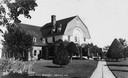
| Date: | 1915 |
|---|---|
| Description: | View of the State Fish Hatchery, surrounded by a lawn planted with trees. A wide sidewalk leads up to the entrance. The sign on the front of the building r... |
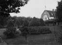
| Date: | 1915 |
|---|---|
| Description: | View towards the front of the State Fish Hatchery from the surrounding grounds. |
| Date: | 1915 |
|---|---|
| Description: | Building, boats, and fish net drying reels on South Twin Island in the Apostle Islands archipelago. |
| Date: | 1910 |
|---|---|
| Description: | View towards shoreline of an automobile being driven on the Bayfield City Dock. Colonel Woods' boat, "Nebraska" is at the dock. Sam Fifields' "Stella" is a... |

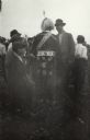
| Date: | 07 04 1913 |
|---|---|
| Description: | Indian "Powwow" and Lacrosse contest between various Indian reservations. |
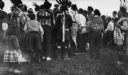
| Date: | 1913 |
|---|---|
| Description: | Powwow at the Red Cliff Indian Reservation on the shores of Lake Superior. |
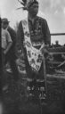
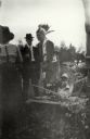
| Date: | 1913 |
|---|---|
| Description: | Native American at a Red Cliff Indian Reservation Powwow on the shores of Lake Superior. |
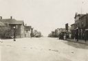
| Date: | 1916 |
|---|---|
| Description: | View looking down the center of road, with storefronts and dwellings on both sides. Automobiles and horse-drawn vehicles are parked at various points along... |

| Date: | 1917 |
|---|---|
| Description: | This map, which highlights the land for sale by the Rust-Owen Lumber Company in the towns of Drummond, Cable and Grandview, Bayfield County, Wisconsin, sho... |

| Date: | 1917 |
|---|---|
| Description: | This 1917 map of Bayfield County, Wisconsin, shows the township and range system, towns, sections, cities and villages, railroads, wagon roads, and lakes a... |

| Date: | 1910 |
|---|---|
| Description: | This map is ink and pen on tracing cloth and shows plat of the town, local streets, county roads, railroads, school houses, town halls, hotels, sheds, barn... |

| Date: | 1919 |
|---|---|
| Description: | This map is a topographical map and has relief shown by contours. The map shows roads, state highways, hotels, town halls, school houses, stores, barns, de... |
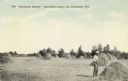
| Date: | 1910 |
|---|---|
| Description: | Photographic postcard view of an open hay field with stacks of hay. The farmer in the right foreground is working on a haystack. Caption reads: "The 'Drumm... |
| Date: | 07 04 1913 |
|---|---|
| Description: | Indian "pow-wow" and lacrosse contest between various reservations. |
| Date: | 07 04 1913 |
|---|---|
| Description: | Indian "pow-wow" and lacrosse contest between various reservations. |
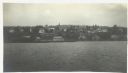
| Date: | 1916 |
|---|---|
| Description: | View across Lake Superior towards Bayfield. |

| Date: | 1912 |
|---|---|
| Description: | This map shows a school reserve, swamp land, railroads, and selected buildings. |
If you didn't find the material you searched for, our Library Reference Staff can help.
Call our reference desk at 608-264-6535 or email us at: