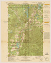
| Date: | 1971 |
|---|---|
| Description: | A topgraphical map of Cable, Wisconsin showing railroads. |
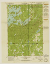
| Date: | 1971 |
|---|---|
| Description: | A topographical map of Namekagon Lake and the surrounding area. |

| Date: | 1979 |
|---|---|
| Description: | David and Joan Obey (right) with Senator Gaylord Nelson (2nd from left) and Secretary of the Interior Cecil Andrus (on Nelson's left) on an Apostle Islands... |

| Date: | 02 01 1970 |
|---|---|
| Description: | A man is skiing down a snow-covered hill at Mt. Ashwabay Ski and Recreation Area. |
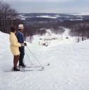
| Date: | 02 01 1970 |
|---|---|
| Description: | A man and a woman are standing on their skis looking down the ski hill looking down at the landscape below. |
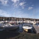
| Date: | 10 1978 |
|---|---|
| Description: | View from shoreline towards motorboats and sailboats docked in a marina. In the distance are buildings on a hill among trees. |
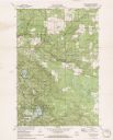
| Date: | 1971 |
|---|---|
| Description: | A topographical map of the Grand View NW quadrangle. |
If you didn't find the material you searched for, our Library Reference Staff can help.
Call our reference desk at 608-264-6535 or email us at: