Filter: Categories of Wisconsin Historical Images
Filter: County of Bayfield
Filter: Year of 1900-1999
Filter: Subject of botany
Filter: Creator Name of Unknown
Filter: Categories of Wisconsin Historical Images
Filter: County of Bayfield
Filter: Year of 1900-1999
Filter: Subject of botany
Filter: Creator Name of Unknown
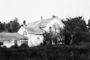
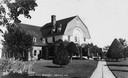
| Date: | 1930 |
|---|---|
| Description: | View of the E. Pike residence. The owner is thought to have been a relative of Robinson D. Pike (1838-1905), a lumber merchant and the founder of Bayfield... |
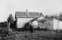
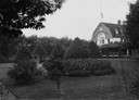
| Date: | 1930 |
|---|---|
| Description: | Back view of the E. Pike residence. A man is standing in the center. The owner is thought to have been a relative of Robinson D. Pike (1838-1905), a lumber... |
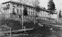
| Date: | 1920 |
|---|---|
| Description: | Pureair Sanatorium, a tuberculosis sanatorium. |
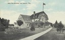
| Date: | 1915 |
|---|---|
| Description: | View of the State Fish Hatchery, surrounded by a lawn planted with trees. A wide sidewalk leads up to the entrance. The sign on the front of the building r... |
| Date: | 1915 |
|---|---|
| Description: | View towards the front of the State Fish Hatchery from the surrounding grounds. |
| Date: | 1930 |
|---|---|
| Description: | View of the State Fish Hatchery. Caption reads: "State Fish Hatchery, near Ashland, Wis." |
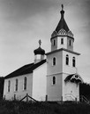
| Date: | 1948 |
|---|---|
| Description: | Exterior of St. Mary's Russian Orthodox Church. |
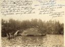
| Date: | 1904 |
|---|---|
| Description: | View across water towards Brower Park near Houghton Point. |
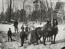
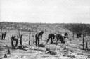
| Date: | 1904 |
|---|---|
| Description: | Winter scene with lumber workers hauling a large log with horses. |

| Date: | 1908 |
|---|---|
| Description: | Left to right, Maria, Fred, Oscar, and Alma Getto standing in a field. Henry Getto is in a horse-drawn wagon in the background. |

| Date: | 1935 |
|---|---|
| Description: | This pictorial map of northern Bayfield County, Wisconsin, shows the Chequamegon National Forest, the Red Cliff Indian Reservation, highways and roads, and... |

| Date: | 1967 |
|---|---|
| Description: | This tourist brochure for Bayfield County, Wisconsin, from 1967 includes a map of the county showing towns, cities and villages, highways and roads, railro... |
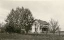
| Date: | 1931 |
|---|---|
| Description: | A one and a half story wood frame house stands behind a wire fence. Wildflowers bloom in the yard and there are several trees near the house. Lightning ro... |
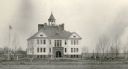
| Date: | 1931 |
|---|---|
| Description: | Children play on swings in front of the imposing Port Wing Consolidated School. It is two stories tall, with wood frame construction, a tall sandstone foun... |
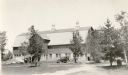
| Date: | 1931 |
|---|---|
| Description: | An automobile is parked near the Melvin Larson barn in Bayfield County. The large barn has a concrete block foundation, gambrel roof, and three large venti... |

| Date: | 1979 |
|---|---|
| Description: | David and Joan Obey (right) with Senator Gaylord Nelson (2nd from left) and Secretary of the Interior Cecil Andrus (on Nelson's left) on an Apostle Islands... |
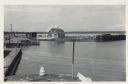
| Date: | 06 19 1958 |
|---|---|
| Description: | Slightly elevated view of Cornucopia Harbor. There is a boat moored at a pier near a barn-shaped building. An automobile is parked on the far left. In the ... |
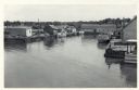
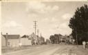
| Date: | 06 19 1958 |
|---|---|
| Description: | Slightly elevated view over water towards East slip in Cornucopia Harbor. There is a small cluster of buildings along the left and right sides with boats m... |
If you didn't find the material you searched for, our Library Reference Staff can help.
Call our reference desk at 608-264-6535 or email us at: