 Filter: Categories of Wisconsin Historical Images
Filter: County of Bayfield
Filter: Year of 1900-1999
Filter: Subject of aerial photographs
Filter: Categories of Wisconsin Historical Images
Filter: County of Bayfield
Filter: Year of 1900-1999
Filter: Subject of aerial photographs
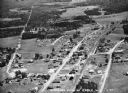
| Date: | 1936 |
|---|---|
| Description: | Aerial view of Cable, in northern Wisconsin. Text at foot reads: "Airplane View of Cable, Wis. 244." |
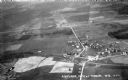
| Date: | 1931 |
|---|---|
| Description: | Aerial view taken from an airplane overlooking the town of Mason. Farm fields, roads, trees, houses and other buildings are visible. |
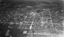
| Date: | 1935 |
|---|---|
| Description: | Aerial view, taken from an airplane, overlooking the streets, houses, stores, trees and railroad cars. |

| Date: | 1937 |
|---|---|
| Description: | Aerial view of Lake Owen between Cable and Drummond. |

| Date: | 1929 |
|---|---|
| Description: | Aerial view of Lake Namakagon, showing the roads that connect Anderson Island (center left), and Juneks Point, Eagle Point, and Paines Island. |
If you didn't find the material you searched for, our Library Reference Staff can help.
Call our reference desk at 608-264-6535 or email us at:
