 Filter: Categories of Wisconsin Historical Images
Filter: County of Bayfield
Filter: Year of 1800-1899
Filter: Year of 1890-1899
Filter: Categories of Wisconsin Historical Images
Filter: County of Bayfield
Filter: Year of 1800-1899
Filter: Year of 1890-1899

| Date: | 1896 |
|---|---|
| Description: | Bird's-eye view of Washburn, with twenty vignettes around side, water in foreground with docks and lumber corral. Thirty-three locations identified in key ... |
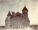
| Date: | 1898 |
|---|---|
| Description: | Walker High School, located near the intersection of Washington Avenue and West Ninth Street. View looking northwest. |
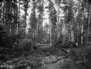
| Date: | 09 06 1895 |
|---|---|
| Description: | View of a partially harvested pine forest nine miles southwest of Washburn. A pathway is being cut for a narrow gauge logging railroad. |
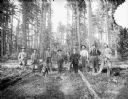
| Date: | 1895 |
|---|---|
| Description: | A group of well-dressed men and a dog pose in a forested area. |

| Date: | 1892 |
|---|---|
| Description: | This map of Bayfield shows roads, lots, and township boundaries. The map was originally published on one sheet but is now separated into front and back. On... |
If you didn't find the material you searched for, our Library Reference Staff can help.
Call our reference desk at 608-264-6535 or email us at: